
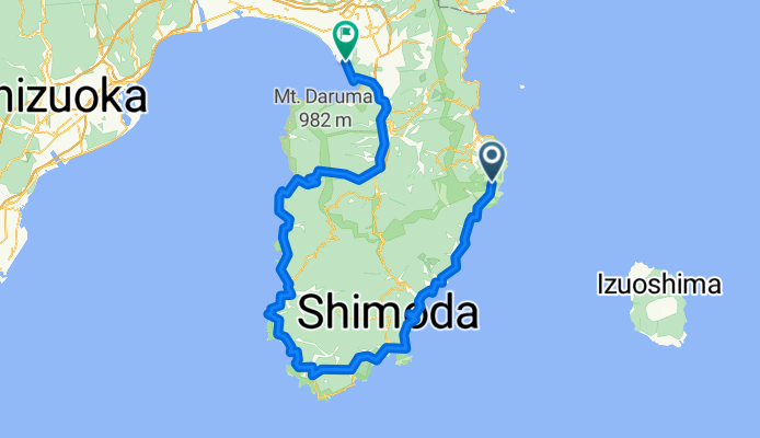
2009-08 Day 2 (Izu-Numazu)
A cycling route starting in Itō, Shizuoka, Japan.
Overview
About this route
- -:--
- Duration
- 147.1 km
- Distance
- 1,581 m
- Ascent
- 1,807 m
- Descent
- ---
- Avg. speed
- ---
- Avg. speed

Continue with Bikemap
Use, edit, or download this cycling route
You would like to ride 2009-08 Day 2 (Izu-Numazu) or customize it for your own trip? Here is what you can do with this Bikemap route:
Free features
- Save this route as favorite or in collections
- Copy & plan your own version of this route
- Sync your route with Garmin or Wahoo
Premium features
Free trial for 3 days, or one-time payment. More about Bikemap Premium.
- Navigate this route on iOS & Android
- Export a GPX / KML file of this route
- Create your custom printout (try it for free)
- Download this route for offline navigation
Discover more Premium features.
Get Bikemap PremiumFrom our community
Other popular routes starting in Itō
 2009-08 Day 2 (Izu-Numazu)
- Distance
- 147.1 km
- Ascent
- 1,581 m
- Descent
- 1,807 m
- Location
- Itō, Shizuoka, Japan
 IZU - Japan Cycle Sport circuiit
- Distance
- 12.3 km
- Ascent
- 356 m
- Descent
- 354 m
- Location
- Itō, Shizuoka, Japan
 Ito to Shimoda
- Distance
- 53.7 km
- Ascent
- 687 m
- Descent
- 684 m
- Location
- Itō, Shizuoka, Japan
 izu : Ito a shuzenji par cascade et Onsen
- Distance
- 32.5 km
- Ascent
- 597 m
- Descent
- 559 m
- Location
- Itō, Shizuoka, Japan
 Shuzenji > Numazu
- Distance
- 23.8 km
- Ascent
- 60 m
- Descent
- 116 m
- Location
- Itō, Shizuoka, Japan
 IZU - Japan Cycle Sport circuiit
- Distance
- 12.3 km
- Ascent
- 356 m
- Descent
- 355 m
- Location
- Itō, Shizuoka, Japan
 修善寺駅, 伊豆市 to 修善寺駅, 伊豆市
- Distance
- 42.6 km
- Ascent
- 2,175 m
- Descent
- 2,175 m
- Location
- Itō, Shizuoka, Japan
 971-21, Naramoto, Higashiizu-Cho, Kamo-Gun to Hiyoshihoncho 1-Chōme, Kohoku-Ku, Yokohama-Shi
- Distance
- 137.1 km
- Ascent
- 2,640 m
- Descent
- 2,655 m
- Location
- Itō, Shizuoka, Japan
Open it in the app