

30km Sindelfingen, Renningen & zurück
A cycling route starting in Sindelfingen, Baden-Württemberg, Germany.
Overview
About this route
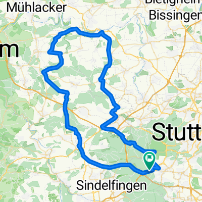
Startpunkt Tankstelle Pfarrwiesenallee. Waldweg geteert Richtung Nord Richtung Magstadt / Hölzertal. Im Hölzertal nach Magstadt, über die kleine Verbindungsstrasse ins Warmbronner Tal und dann nach Renningen. Weiter nach Malmsheim und auf beschildertem Radweg nach Weil der Stadt. Durchs Tal an der Säge vorbei nach Döffingen. Dort an der oberen Kirche rechts über die Felder nach Sindelfingen zurück.
- -:--
- Duration
- 32 km
- Distance
- 209 m
- Ascent
- 226 m
- Descent
- ---
- Avg. speed
- 502 m
- Avg. speed
Route quality
Waytypes & surfaces along the route
Waytypes
Track
14.1 km
(44 %)
Quiet road
8.3 km
(26 %)
Surfaces
Paved
30.7 km
(96 %)
Unpaved
0.4 km
(1 %)
Asphalt
28.7 km
(90 %)
Paved (undefined)
1.1 km
(4 %)
Continue with Bikemap
Use, edit, or download this cycling route
You would like to ride 30km Sindelfingen, Renningen & zurück or customize it for your own trip? Here is what you can do with this Bikemap route:
Free features
- Save this route as favorite or in collections
- Copy & plan your own version of this route
- Sync your route with Garmin or Wahoo
Premium features
Free trial for 3 days, or one-time payment. More about Bikemap Premium.
- Navigate this route on iOS & Android
- Export a GPX / KML file of this route
- Create your custom printout (try it for free)
- Download this route for offline navigation
Discover more Premium features.
Get Bikemap PremiumFrom our community
Other popular routes starting in Sindelfingen
 einfach drauf los
- Distance
- 36.7 km
- Ascent
- 391 m
- Descent
- 389 m
- Location
- Sindelfingen, Baden-Württemberg, Germany
 S-Vaihingen Renningen Mönse Iptingen Gr-Glattbach Enzweihingen Heimse Leo
- Distance
- 79.4 km
- Ascent
- 878 m
- Descent
- 975 m
- Location
- Sindelfingen, Baden-Württemberg, Germany
 Kurze Runde um BB (62,5km)
- Distance
- 62.5 km
- Ascent
- 454 m
- Descent
- 439 m
- Location
- Sindelfingen, Baden-Württemberg, Germany
 Vaihingen Baerenschloessle
- Distance
- 6.2 km
- Ascent
- 94 m
- Descent
- 166 m
- Location
- Sindelfingen, Baden-Württemberg, Germany
 Sindelfingen-Siebenmühlental
- Distance
- 25.1 km
- Ascent
- 215 m
- Descent
- 226 m
- Location
- Sindelfingen, Baden-Württemberg, Germany
 Sindelfingen ins Nagoldtal und durch das Würmtal zurück
- Distance
- 86.6 km
- Ascent
- 624 m
- Descent
- 625 m
- Location
- Sindelfingen, Baden-Württemberg, Germany
 Sifi - Musberg - Waldenbuch - Schönaich - BB - Sifi
- Distance
- 38.9 km
- Ascent
- 314 m
- Descent
- 314 m
- Location
- Sindelfingen, Baden-Württemberg, Germany
 Parkhotel Leinfelden Echterdingen und Siebenmühlental
- Distance
- 30 km
- Ascent
- 302 m
- Descent
- 302 m
- Location
- Sindelfingen, Baden-Württemberg, Germany
Open it in the app