
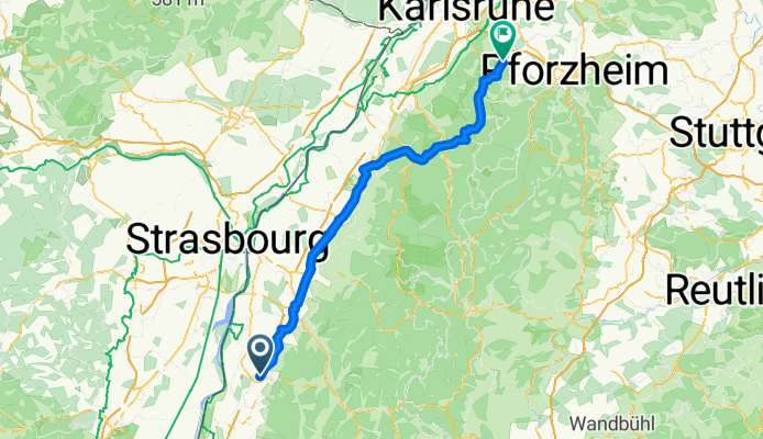
Lahr-Langensteinbach
A cycling route starting in Lahr, Baden-Württemberg, Germany.
Overview
About this route
- -:--
- Duration
- 103.4 km
- Distance
- 724 m
- Ascent
- 550 m
- Descent
- ---
- Avg. speed
- 386 m
- Avg. speed
Route quality
Waytypes & surfaces along the route
Waytypes
Busy road
62 km
(60 %)
Track
14.5 km
(14 %)
Surfaces
Paved
90.6 km
(88 %)
Unpaved
3.9 km
(4 %)
Asphalt
89.5 km
(87 %)
Gravel
2.6 km
(2 %)
Continue with Bikemap
Use, edit, or download this cycling route
You would like to ride Lahr-Langensteinbach or customize it for your own trip? Here is what you can do with this Bikemap route:
Free features
- Save this route as favorite or in collections
- Copy & plan your own version of this route
- Sync your route with Garmin or Wahoo
Premium features
Free trial for 3 days, or one-time payment. More about Bikemap Premium.
- Navigate this route on iOS & Android
- Export a GPX / KML file of this route
- Create your custom printout (try it for free)
- Download this route for offline navigation
Discover more Premium features.
Get Bikemap PremiumFrom our community
Other popular routes starting in Lahr
 Ortenau-Klinikum Gengenbach Rundfahrt
- Distance
- 141.1 km
- Ascent
- 932 m
- Descent
- 930 m
- Location
- Lahr, Baden-Württemberg, Germany
 Lahr Rhinau
- Distance
- 39.6 km
- Ascent
- 34 m
- Descent
- 35 m
- Location
- Lahr, Baden-Württemberg, Germany
 Höhenweg Diersburg
- Distance
- 21.7 km
- Ascent
- 214 m
- Descent
- 212 m
- Location
- Lahr, Baden-Württemberg, Germany
 Schillingsweg 2, Lahr/Schwarzwald nach Schillingsweg 2, Lahr/Schwarzwald
- Distance
- 39.7 km
- Ascent
- 44 m
- Descent
- 120 m
- Location
- Lahr, Baden-Württemberg, Germany
 Schillingsweg 2, Lahr/Schwarzwald nach Schillingsweg 2/4, Lahr/Schwarzwald
- Distance
- 48.5 km
- Ascent
- 874 m
- Descent
- 889 m
- Location
- Lahr, Baden-Württemberg, Germany
 Schuttertal-Geisberg-Kinzigtal
- Distance
- 48.8 km
- Ascent
- 663 m
- Descent
- 663 m
- Location
- Lahr, Baden-Württemberg, Germany
 Schillingsweg 2, Lahr/Schwarzwald nach Schillingsweg 2, Lahr/Schwarzwald
- Distance
- 20.6 km
- Ascent
- 328 m
- Descent
- 402 m
- Location
- Lahr, Baden-Württemberg, Germany
 Rilkestraße nach L118
- Distance
- 26.3 km
- Ascent
- 34 m
- Descent
- 98 m
- Location
- Lahr, Baden-Württemberg, Germany
Open it in the app