

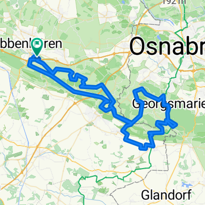
Ibbenbüren-Hopsten-Schapen-Dreierwalde-Hörstel
A cycling route starting in Ibbenbueren, North Rhine-Westphalia, Germany.
Overview
About this route
- -:--
- Duration
- 58.9 km
- Distance
- 47 m
- Ascent
- 51 m
- Descent
- ---
- Avg. speed
- ---
- Avg. speed

Route quality
Waytypes & surfaces along the route
Waytypes
Quiet road
34.8 km
(59 %)
Path
9.1 km
(15 %)
Surfaces
Paved
35.6 km
(60 %)
Unpaved
6.3 km
(11 %)
Asphalt
23.5 km
(40 %)
Paved (undefined)
11.3 km
(19 %)
Continue with Bikemap
Use, edit, or download this cycling route
You would like to ride Ibbenbüren-Hopsten-Schapen-Dreierwalde-Hörstel or customize it for your own trip? Here is what you can do with this Bikemap route:
Free features
- Save this route as favorite or in collections
- Copy & plan your own version of this route
- Sync your route with Garmin or Wahoo
Premium features
Free trial for 3 days, or one-time payment. More about Bikemap Premium.
- Navigate this route on iOS & Android
- Export a GPX / KML file of this route
- Create your custom printout (try it for free)
- Download this route for offline navigation
Discover more Premium features.
Get Bikemap PremiumFrom our community
Other popular routes starting in Ibbenbueren
 Ibbenbüren - Wersen
- Distance
- 39.8 km
- Ascent
- 210 m
- Descent
- 210 m
- Location
- Ibbenbueren, North Rhine-Westphalia, Germany
 EB_MUENS_008 - Auf den Spuren des Töddenlands
- Distance
- 54.5 km
- Ascent
- 530 m
- Descent
- 530 m
- Location
- Ibbenbueren, North Rhine-Westphalia, Germany
 TECKELENBURG RONDE
- Distance
- 101.2 km
- Ascent
- 868 m
- Descent
- 867 m
- Location
- Ibbenbueren, North Rhine-Westphalia, Germany
 Teutoburgerwaldtocht 85km
- Distance
- 86.5 km
- Ascent
- 960 m
- Descent
- 922 m
- Location
- Ibbenbueren, North Rhine-Westphalia, Germany
 Teutoburgerwaldtocht
- Distance
- 86.7 km
- Ascent
- 1,002 m
- Descent
- 941 m
- Location
- Ibbenbueren, North Rhine-Westphalia, Germany
 Lagg-FMO-Lagg
- Distance
- 59.5 km
- Ascent
- 227 m
- Descent
- 228 m
- Location
- Ibbenbueren, North Rhine-Westphalia, Germany
 Von Ibbenbüren bis Spelle
- Distance
- 23.5 km
- Ascent
- 30 m
- Descent
- 68 m
- Location
- Ibbenbueren, North Rhine-Westphalia, Germany
 Teutorundfahrt
- Distance
- 36.5 km
- Ascent
- 135 m
- Descent
- 138 m
- Location
- Ibbenbueren, North Rhine-Westphalia, Germany
Open it in the app