

20161025_085424.gpx
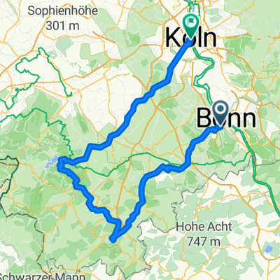
A cycling route starting in Bonn, North Rhine-Westphalia, Germany.
Overview
About this route
TAHUNA track
- -:--
- Duration
- 10.2 km
- Distance
- 140 m
- Ascent
- 30 m
- Descent
- ---
- Avg. speed
- ---
- Avg. speed
Route quality
Waytypes & surfaces along the route
Waytypes
Quiet road
4 km
(39 %)
Access road
1.9 km
(18 %)
Surfaces
Paved
10.1 km
(99 %)
Unpaved
0.1 km
(1 %)
Asphalt
8.4 km
(82 %)
Paving stones
1.4 km
(13 %)
Continue with Bikemap
Use, edit, or download this cycling route
You would like to ride 20161025_085424.gpx or customize it for your own trip? Here is what you can do with this Bikemap route:
Free features
- Save this route as favorite or in collections
- Copy & plan your own version of this route
- Sync your route with Garmin or Wahoo
Premium features
Free trial for 3 days, or one-time payment. More about Bikemap Premium.
- Navigate this route on iOS & Android
- Export a GPX / KML file of this route
- Create your custom printout (try it for free)
- Download this route for offline navigation
Discover more Premium features.
Get Bikemap PremiumFrom our community
Other popular routes starting in Bonn
 BRT2016-FR: An Rhein und Sieg - PSF des Radsportbezirk Mittelrhein-Süd beim BRT 2016 in Bonn - 76 km Strecke
- Distance
- 74.9 km
- Ascent
- 509 m
- Descent
- 509 m
- Location
- Bonn, North Rhine-Westphalia, Germany
 Auf den Feldern zwischen Köln und Troisdorf
- Distance
- 29.5 km
- Ascent
- 23 m
- Descent
- 24 m
- Location
- Bonn, North Rhine-Westphalia, Germany
 Ahrtal-Eifel-Kottenforst
- Distance
- 80.9 km
- Ascent
- 925 m
- Descent
- 910 m
- Location
- Bonn, North Rhine-Westphalia, Germany
 T-Mobile-Rheinauen-Mehlem-Köwi-Dollendorf-Rheinauen-T-Mobile
- Distance
- 15.6 km
- Ascent
- 50 m
- Descent
- 50 m
- Location
- Bonn, North Rhine-Westphalia, Germany
 kleine McDrive-Runde (Ittenbach)
- Distance
- 40.7 km
- Ascent
- 437 m
- Descent
- 437 m
- Location
- Bonn, North Rhine-Westphalia, Germany
 Bonn - Stadt Blankenberg
- Distance
- 79.5 km
- Ascent
- 846 m
- Descent
- 846 m
- Location
- Bonn, North Rhine-Westphalia, Germany
 Bonn - Ahrquelle - Rursee - Köln
- Distance
- 154 km
- Ascent
- 987 m
- Descent
- 1,006 m
- Location
- Bonn, North Rhine-Westphalia, Germany
 Flach um Bonn
- Distance
- 56.6 km
- Ascent
- 186 m
- Descent
- 186 m
- Location
- Bonn, North Rhine-Westphalia, Germany
Open it in the app