
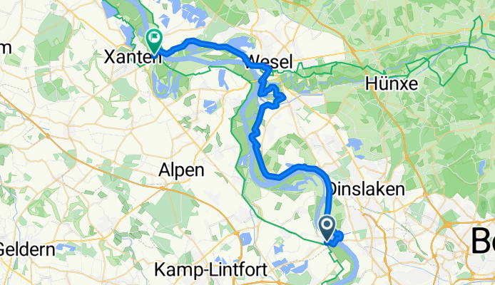
B06-Orsoy-Xanten-Fähre-rechtsrheinisch
A cycling route starting in Dinslaken, North Rhine-Westphalia, Germany.
Overview
About this route
2mal übersetzen mit Fähren (eingeschränkte Fahrzeiten, Saisonal am Wochenende und mittwochs
- -:--
- Duration
- 39.7 km
- Distance
- 93 m
- Ascent
- 105 m
- Descent
- ---
- Avg. speed
- ---
- Avg. speed
Route quality
Waytypes & surfaces along the route
Waytypes
Path
11.3 km
(29 %)
Track
9.7 km
(25 %)
Surfaces
Paved
18.4 km
(46 %)
Unpaved
10.1 km
(25 %)
Asphalt
17.3 km
(44 %)
Gravel
9.2 km
(23 %)
Continue with Bikemap
Use, edit, or download this cycling route
You would like to ride B06-Orsoy-Xanten-Fähre-rechtsrheinisch or customize it for your own trip? Here is what you can do with this Bikemap route:
Free features
- Save this route as favorite or in collections
- Copy & plan your own version of this route
- Sync your route with Garmin or Wahoo
Premium features
Free trial for 3 days, or one-time payment. More about Bikemap Premium.
- Navigate this route on iOS & Android
- Export a GPX / KML file of this route
- Create your custom printout (try it for free)
- Download this route for offline navigation
Discover more Premium features.
Get Bikemap PremiumFrom our community
Other popular routes starting in Dinslaken
 Walsumer Krudenburg Runde
- Distance
- 56.4 km
- Ascent
- 151 m
- Descent
- 146 m
- Location
- Dinslaken, North Rhine-Westphalia, Germany
 Ob nach Din - Beliebt 2
- Distance
- 9.2 km
- Ascent
- 18 m
- Descent
- 24 m
- Location
- Dinslaken, North Rhine-Westphalia, Germany
 Ob nach Din - Beliebt
- Distance
- 9.7 km
- Ascent
- 14 m
- Descent
- 21 m
- Location
- Dinslaken, North Rhine-Westphalia, Germany
 21 Rotbach - Rhein - HOAG - Runde
- Distance
- 31.4 km
- Ascent
- 99 m
- Descent
- 99 m
- Location
- Dinslaken, North Rhine-Westphalia, Germany
 Hennes Route 1
- Distance
- 39.5 km
- Ascent
- 128 m
- Descent
- 129 m
- Location
- Dinslaken, North Rhine-Westphalia, Germany
 Din nach Ob - Beliebt 2
- Distance
- 9.2 km
- Ascent
- 23 m
- Descent
- 19 m
- Location
- Dinslaken, North Rhine-Westphalia, Germany
 Heidesee-Grafenmühle-Gasometer
- Distance
- 39.3 km
- Ascent
- 77 m
- Descent
- 77 m
- Location
- Dinslaken, North Rhine-Westphalia, Germany
 Mattlerhof RTF - 43 km Runde
- Distance
- 43.1 km
- Ascent
- 170 m
- Descent
- 168 m
- Location
- Dinslaken, North Rhine-Westphalia, Germany
Open it in the app