

Etschradweg 2017 5. Etappe.gpx
A cycling route starting in Merano, Trentino-Alto Adige, Italy.
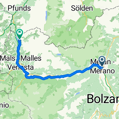
Overview
About this route
TAHUNA track
- -:--
- Duration
- 62.5 km
- Distance
- 311 m
- Ascent
- 152 m
- Descent
- ---
- Avg. speed
- ---
- Avg. speed

Route quality
Waytypes & surfaces along the route
Waytypes
Cycleway
32.2 km
(52 %)
Path
10.6 km
(17 %)
Surfaces
Paved
56.6 km
(91 %)
Unpaved
0 km
(<1 %)
Asphalt
56.3 km
(90 %)
Paving stones
0.2 km
(<1 %)
Continue with Bikemap
Use, edit, or download this cycling route
You would like to ride Etschradweg 2017 5. Etappe.gpx or customize it for your own trip? Here is what you can do with this Bikemap route:
Free features
- Save this route as favorite or in collections
- Copy & plan your own version of this route
- Sync your route with Garmin or Wahoo
Premium features
Free trial for 3 days, or one-time payment. More about Bikemap Premium.
- Navigate this route on iOS & Android
- Export a GPX / KML file of this route
- Create your custom printout (try it for free)
- Download this route for offline navigation
Discover more Premium features.
Get Bikemap PremiumFrom our community
Other popular routes starting in Merano
 Alpenüberquerung 4/5 Meran - Cles
- Distance
- 54 km
- Ascent
- 1,385 m
- Descent
- 1,044 m
- Location
- Merano, Trentino-Alto Adige, Italy
- Route nach Bardolino
- Distance
- 538.3 km
- Ascent
- 1,503 m
- Descent
- 1,680 m
- Location
- Merano, Trentino-Alto Adige, Italy
 Meran-St. Leonhard in Passeier
- Distance
- 21.5 km
- Ascent
- 619 m
- Descent
- 300 m
- Location
- Merano, Trentino-Alto Adige, Italy
 Day5: Merano to Klausen
- Distance
- 70.8 km
- Ascent
- 1,665 m
- Descent
- 821 m
- Location
- Merano, Trentino-Alto Adige, Italy
 Meran_Mölten_Meran
- Distance
- 58 km
- Ascent
- 1,930 m
- Descent
- 1,219 m
- Location
- Merano, Trentino-Alto Adige, Italy
 I - Südtirol - Durch die Obstgärten - 59 km
- Distance
- 58.8 km
- Ascent
- 235 m
- Descent
- 237 m
- Location
- Merano, Trentino-Alto Adige, Italy
 Zum Talbauer hoch über Meran
- Distance
- 27.5 km
- Ascent
- 1,021 m
- Descent
- 1,023 m
- Location
- Merano, Trentino-Alto Adige, Italy
 Montag
- Distance
- 77.6 km
- Ascent
- 1,713 m
- Descent
- 512 m
- Location
- Merano, Trentino-Alto Adige, Italy
Open it in the app