

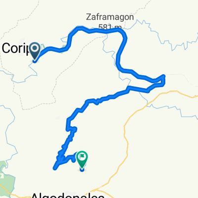
Vía Verde de la Sierra: Coripe-Olvera
A cycling route starting in Coripe, Andalusia, Spain.
Overview
About this route
<span style="font-family: GillSans-Light; color: #231f20; font-size: x-small;"><font face="GillSans-Light" size="2" color="#231f20"><font face="GillSans-Light" size="2" color="#231f20">
<font face="Times New Roman"><span style="font-family: GillSans-Light; color: #231f20; mso-bidi-font-family: GillSans-Light;">La Vía Verde de la Sierra</span><span style="font-family: GillSans-Light; color: #231f20; mso-bidi-font-family: GillSans-Light;"> discurre durante 36 km. por el antiguo trazado ferroviario Jerez-Almargen, entre las provincias de Cádiz y Sevilla, uniendo las localidades de Olvera y Puerto Serrano. Se trata de un itinerario ecoturístico para realizar a pie, en bici, a caballo e incluso en burro que permitirá al excursionista contemplar una naturaleza exuberante, valiosas especies animales y vegetales y paisajes de ensueño.</span></font>
<span style="font-family: GillSans-Light; color: #231f20; mso-bidi-font-family: GillSans-Light;"><font face="Times New Roman"> </font></span>
<span style="font-family: GillSans-Light; color: #231f20; mso-bidi-font-family: GillSans-Light;"><font face="Times New Roman">La ruta se inicia en la antigua Estación de Olvera en cuyo edificio de viajeros se ha instalado un encantador alojamiento rural con restaurante. Un rosario de túneles vigilados por las cuencas de los ríos Guadalporcún y Guadamanil nos conducirá entre fincas y olivares, tras dejar atrás la Estación de Navalagrulla y el Área Recreativa de la Colada de Morón, hasta el paraje estrella de la Vía Verde: la Reserva Natural del Peñón de Zaframagón, una de las mayores colonias de buitres leonados de Europa.</font></span><span style="font-family: Tahoma; color: navy; font-size: 9pt; mso-bidi-font-style: italic; mso-bidi-font-size: 10.0pt;"></span>
</font></font></span>
- -:--
- Duration
- 21 km
- Distance
- 579 m
- Ascent
- 344 m
- Descent
- ---
- Avg. speed
- ---
- Avg. speed

Continue with Bikemap
Use, edit, or download this cycling route
You would like to ride Vía Verde de la Sierra: Coripe-Olvera or customize it for your own trip? Here is what you can do with this Bikemap route:
Free features
- Save this route as favorite or in collections
- Copy & plan your own version of this route
- Sync your route with Garmin or Wahoo
Premium features
Free trial for 3 days, or one-time payment. More about Bikemap Premium.
- Navigate this route on iOS & Android
- Export a GPX / KML file of this route
- Create your custom printout (try it for free)
- Download this route for offline navigation
Discover more Premium features.
Get Bikemap PremiumFrom our community
Other popular routes starting in Coripe
 Route to Zahara
- Distance
- 26.2 km
- Ascent
- 1,137 m
- Descent
- 956 m
- Location
- Coripe, Andalusia, Spain
 Las Palomas desde Coripe
- Distance
- 92.8 km
- Ascent
- 1,452 m
- Descent
- 1,451 m
- Location
- Coripe, Andalusia, Spain
 Coripe, Algodonales, El Gastor, Olvera, La Muela, Coripe
- Distance
- 96.1 km
- Ascent
- 1,210 m
- Descent
- 1,208 m
- Location
- Coripe, Andalusia, Spain
 MOGOTAZO www.forociclismo.net
- Distance
- 51.5 km
- Ascent
- 1,095 m
- Descent
- 1,111 m
- Location
- Coripe, Andalusia, Spain
 Estación Coripe-La Toleta-Zaframagón-Circular
- Distance
- 45.7 km
- Ascent
- 653 m
- Descent
- 645 m
- Location
- Coripe, Andalusia, Spain
 Setenil
- Distance
- 115 km
- Ascent
- 2,029 m
- Descent
- 2,032 m
- Location
- Coripe, Andalusia, Spain
 Vuelta por Coripe-La Muela
- Distance
- 32.1 km
- Ascent
- 936 m
- Descent
- 527 m
- Location
- Coripe, Andalusia, Spain
 Ciclismo por la tarde🚴☀️🌡️
- Distance
- 44.5 km
- Ascent
- 731 m
- Descent
- 776 m
- Location
- Coripe, Andalusia, Spain
Open it in the app