

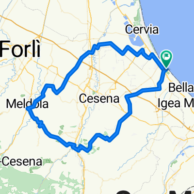
Cesenatico--Pineta di Cervia Cesenatico
A cycling route starting in Cesenatico, Emilia-Romagna, Italy.
Overview
About this route
Fatrabike
- -:--
- Duration
- 43.7 km
- Distance
- 18 m
- Ascent
- 22 m
- Descent
- ---
- Avg. speed
- ---
- Avg. speed

Route quality
Waytypes & surfaces along the route
Waytypes
Road
16 km
(37 %)
Quiet road
11.4 km
(26 %)
Surfaces
Paved
20.7 km
(47 %)
Unpaved
6.7 km
(15 %)
Asphalt
20.7 km
(47 %)
Ground
5.5 km
(13 %)
Continue with Bikemap
Use, edit, or download this cycling route
You would like to ride Cesenatico--Pineta di Cervia Cesenatico or customize it for your own trip? Here is what you can do with this Bikemap route:
Free features
- Save this route as favorite or in collections
- Copy & plan your own version of this route
- Sync your route with Garmin or Wahoo
Premium features
Free trial for 3 days, or one-time payment. More about Bikemap Premium.
- Navigate this route on iOS & Android
- Export a GPX / KML file of this route
- Create your custom printout (try it for free)
- Download this route for offline navigation
Discover more Premium features.
Get Bikemap PremiumFrom our community
Other popular routes starting in Cesenatico
 Cesenatico/Emilia Romagna '01: Tour 3 - 'Meldola'
- Distance
- 83.7 km
- Ascent
- 360 m
- Descent
- 363 m
- Location
- Cesenatico, Emilia-Romagna, Italy
 Roncofreddo
- Distance
- 53.9 km
- Ascent
- 327 m
- Descent
- 330 m
- Location
- Cesenatico, Emilia-Romagna, Italy
 C-2018-Bertinoro
- Distance
- 75.2 km
- Ascent
- 422 m
- Descent
- 424 m
- Location
- Cesenatico, Emilia-Romagna, Italy
 Tavullia
- Distance
- 140.9 km
- Ascent
- 1,097 m
- Descent
- 1,099 m
- Location
- Cesenatico, Emilia-Romagna, Italy
 Cesenatico - Bertinoro - Monte Cavallo - Dialoguardia - Cesenatico
- Distance
- 95.2 km
- Ascent
- 852 m
- Descent
- 854 m
- Location
- Cesenatico, Emilia-Romagna, Italy
 Nove colli 2009 130 km
- Distance
- 129.7 km
- Ascent
- 2,065 m
- Descent
- 1,906 m
- Location
- Cesenatico, Emilia-Romagna, Italy
 Road: Cesenatico: last day
- Distance
- 60.6 km
- Ascent
- 550 m
- Descent
- 548 m
- Location
- Cesenatico, Emilia-Romagna, Italy
 C-2020 Veruchio-Dognana-Santarcangelo
- Distance
- 73.6 km
- Ascent
- 393 m
- Descent
- 394 m
- Location
- Cesenatico, Emilia-Romagna, Italy
Open it in the app