
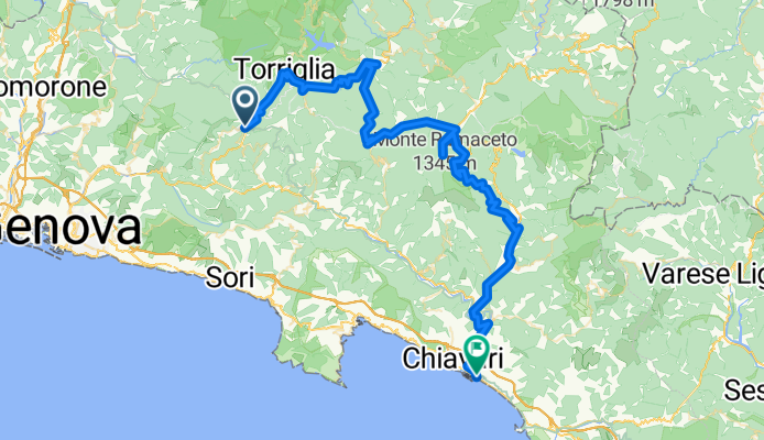
passo della Scoffera-Torriglia-Barbagelata-Ventarola-Lavagna
A cycling route starting in Davagna, Liguria, Italy.
Overview
About this route
Variante del percorso "Lavagna-Gattorna-Casella-Genova".
Dal Passo della Scoffera si raggiunge Torriglia, poi Montebruno, Barbagelata e si arriva al Rifugio Ventarola. Il percorso torna a Palazzuolo per poi scendere al Passo della Forcella e poi, seguendo Via Acer fino a sud di Borzonasca.
Ora si segue la SWP dell'Aveto fino a Carasco, dove ci si immette sulla ciclopedonale fino a Lavagna
- -:--
- Duration
- 79.5 km
- Distance
- 775 m
- Ascent
- 1,449 m
- Descent
- ---
- Avg. speed
- ---
- Avg. speed
Route quality
Waytypes & surfaces along the route
Waytypes
Busy road
45.7 km
(58 %)
Road
14.8 km
(19 %)
Surfaces
Paved
36.9 km
(46 %)
Unpaved
1.4 km
(2 %)
Asphalt
36.9 km
(46 %)
Unpaved (undefined)
1.1 km
(1 %)
Continue with Bikemap
Use, edit, or download this cycling route
You would like to ride passo della Scoffera-Torriglia-Barbagelata-Ventarola-Lavagna or customize it for your own trip? Here is what you can do with this Bikemap route:
Free features
- Save this route as favorite or in collections
- Copy & plan your own version of this route
- Sync your route with Garmin or Wahoo
Premium features
Free trial for 3 days, or one-time payment. More about Bikemap Premium.
- Navigate this route on iOS & Android
- Export a GPX / KML file of this route
- Create your custom printout (try it for free)
- Download this route for offline navigation
Discover more Premium features.
Get Bikemap PremiumFrom our community
Other popular routes starting in Davagna
 Rapallo
- Distance
- 63.3 km
- Ascent
- 1,264 m
- Descent
- 1,923 m
- Location
- Davagna, Liguria, Italy
 Percorso 81
- Distance
- 4.4 km
- Ascent
- 153 m
- Descent
- 508 m
- Location
- Davagna, Liguria, Italy
 Cavassolo-Scoffera
- Distance
- 16.6 km
- Ascent
- 896 m
- Descent
- 335 m
- Location
- Davagna, Liguria, Italy
 Da Via Sottocolle 30/A, Davagna a Piazza della Chiesa 3, Torriglia
- Distance
- 7.2 km
- Ascent
- 455 m
- Descent
- 302 m
- Location
- Davagna, Liguria, Italy
 Alta via dei monti liguri tappa 28
- Distance
- 8.5 km
- Ascent
- 538 m
- Descent
- 292 m
- Location
- Davagna, Liguria, Italy
 ANELLO SCOFFERA - SUPER G
- Distance
- 36.2 km
- Ascent
- 1,075 m
- Descent
- 1,075 m
- Location
- Davagna, Liguria, Italy
 Sestri Levante
- Distance
- 56.4 km
- Ascent
- 304 m
- Descent
- 954 m
- Location
- Davagna, Liguria, Italy
 Letzte Etappe
- Distance
- 55.7 km
- Ascent
- 951 m
- Descent
- 1,610 m
- Location
- Davagna, Liguria, Italy
Open it in the app