

Hohenzollern Radweg
A cycling route starting in Wendelstein, Bavaria, Germany.
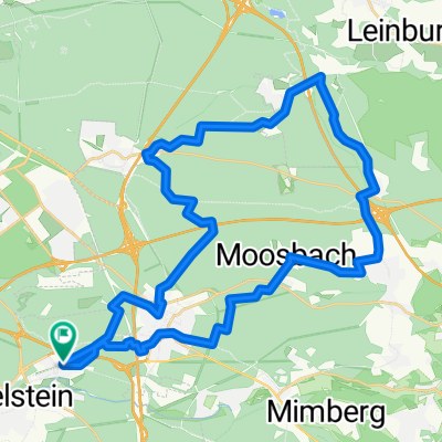
Overview
About this route
Die Spur der Hohenzollern führt Sie von der ehemaligen Kaiserstadt Nürnberg bis in die Residenzstadt Ansbach. Wie Sie der Weg genau führt
- -:--
- Duration
- 80.7 km
- Distance
- 314 m
- Ascent
- 314 m
- Descent
- ---
- Avg. speed
- ---
- Avg. speed
Route quality
Waytypes & surfaces along the route
Waytypes
Path
27.7 km
(34 %)
Quiet road
21.7 km
(27 %)
Surfaces
Paved
56.5 km
(70 %)
Unpaved
11.4 km
(14 %)
Asphalt
52.5 km
(65 %)
Gravel
10.4 km
(13 %)
Continue with Bikemap
Use, edit, or download this cycling route
You would like to ride Hohenzollern Radweg or customize it for your own trip? Here is what you can do with this Bikemap route:
Free features
- Save this route as favorite or in collections
- Copy & plan your own version of this route
- Sync your route with Garmin or Wahoo
Premium features
Free trial for 3 days, or one-time payment. More about Bikemap Premium.
- Navigate this route on iOS & Android
- Export a GPX / KML file of this route
- Create your custom printout (try it for free)
- Download this route for offline navigation
Discover more Premium features.
Get Bikemap PremiumFrom our community
Other popular routes starting in Wendelstein
 Altmühl 1
- Distance
- 203.2 km
- Ascent
- 1,465 m
- Descent
- 1,440 m
- Location
- Wendelstein, Bavaria, Germany
 Testroute mittellang
- Distance
- 13.1 km
- Ascent
- 71 m
- Descent
- 68 m
- Location
- Wendelstein, Bavaria, Germany
 Brunn - Netzstall- Ungelstetten -Runde V 2
- Distance
- 36.9 km
- Ascent
- 376 m
- Descent
- 376 m
- Location
- Wendelstein, Bavaria, Germany
 Runde über die Dörfer
- Distance
- 32.1 km
- Ascent
- 253 m
- Descent
- 250 m
- Location
- Wendelstein, Bavaria, Germany
 5 Flüsse Radweg
- Distance
- 279.6 km
- Ascent
- 317 m
- Descent
- 317 m
- Location
- Wendelstein, Bavaria, Germany
 Altmühl Alles
- Distance
- 369.6 km
- Ascent
- 3,199 m
- Descent
- 3,196 m
- Location
- Wendelstein, Bavaria, Germany
 7. Etappe: Nürnberg-Kornburg - Dietfurt an der Altmühl
- Distance
- 66.5 km
- Ascent
- 207 m
- Descent
- 192 m
- Location
- Wendelstein, Bavaria, Germany
 Schwaig - Ungelstetten1
- Distance
- 41.4 km
- Ascent
- 380 m
- Descent
- 378 m
- Location
- Wendelstein, Bavaria, Germany
Open it in the app