

MTB - Colle di Tenda - ca.4hrs in movement ...excl. Pitstops - Lunch at Ft Pepino
A cycling route starting in Limone Piemonte, Piedmont, Italy.
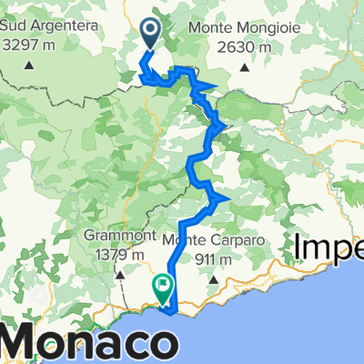
Overview
About this route
A Day excursion in Mtb on Ex-Military Roads ....SingleTracks...some asphalt. Ca.35km long & dsl in positive of 1300mt. Passing some stunning panoramic 360° views over the Marittim Alps, Ft Central, Ft Tabourde, (1950mt a.s.l.), ascending from 1200mt a.s.l. to ca. 2300 mt a.s.l. at Fort Pepino, the highest situated where to absorb the view & to get meritated rest having lunch (picnic) resting the eyes over the panorama. B.Y. O. Water (CamelBak recommended) & Energy intake as NO H2o - Water source is available during the last 3/4 of the ride. Colle di Tenda remains between the Marittime Alps & the Alpe Cozie ...in the history, one of the most important passages for salt, and other merchandises... Today it's part of Parc del Mercantour & Parco delle Alpe Marittime and seperates the Vallyes; Val de Roya and Val Vermenagna. There are 6 fortifications; all constructed during early 18th century ...as to build (order by 'Re di Sardegna) as a defence against an eventual french invasion ....3 of those are included in this route. After the 2nd WW in Paris they were 'given' to France in agreement of italy having lost.
- -:--
- Duration
- 34.3 km
- Distance
- 1,241 m
- Ascent
- 1,241 m
- Descent
- ---
- Avg. speed
- ---
- Avg. speed

Route photos


Route highlights
Points of interest along the route
Photo after 18.1 km
Ft Pepino, mt2330 a.s.l.
Continue with Bikemap
Use, edit, or download this cycling route
You would like to ride MTB - Colle di Tenda - ca.4hrs in movement ...excl. Pitstops - Lunch at Ft Pepino or customize it for your own trip? Here is what you can do with this Bikemap route:
Free features
- Save this route as favorite or in collections
- Copy & plan your own version of this route
- Sync your route with Garmin or Wahoo
Premium features
Free trial for 3 days, or one-time payment. More about Bikemap Premium.
- Navigate this route on iOS & Android
- Export a GPX / KML file of this route
- Create your custom printout (try it for free)
- Download this route for offline navigation
Discover more Premium features.
Get Bikemap PremiumFrom our community
Other popular routes starting in Limone Piemonte
 Itinerari imperdibili in mountain bike. In Piemonte e Valle D'Aosta: 01. La Via del Sale
- Distance
- 38.1 km
- Ascent
- 1,509 m
- Descent
- 1,508 m
- Location
- Limone Piemonte, Piedmont, Italy
 Via del sale Limone-Ventimiglia
- Distance
- 97.6 km
- Ascent
- 4,025 m
- Descent
- 5,025 m
- Location
- Limone Piemonte, Piedmont, Italy
 10 Limone - Ventimiglia
- Distance
- 121.9 km
- Ascent
- 2,474 m
- Descent
- 3,446 m
- Location
- Limone Piemonte, Piedmont, Italy
 Eurovelo 8 - Limone Piedmonte to Torino
- Distance
- 190 km
- Ascent
- 1,597 m
- Descent
- 2,721 m
- Location
- Limone Piemonte, Piedmont, Italy
 Limone - Ventimiglia
- Distance
- 105.8 km
- Ascent
- 2,840 m
- Descent
- 3,813 m
- Location
- Limone Piemonte, Piedmont, Italy
 Limone/ Colle Tenda
- Distance
- 31.7 km
- Ascent
- 829 m
- Descent
- 820 m
- Location
- Limone Piemonte, Piedmont, Italy
 50/2200_Via del Sale Marathon_lp
- Distance
- 51 km
- Ascent
- 1,914 m
- Descent
- 1,901 m
- Location
- Limone Piemonte, Piedmont, Italy
 Transalp Maritime II
- Distance
- 313.7 km
- Ascent
- 1,760 m
- Descent
- 2,753 m
- Location
- Limone Piemonte, Piedmont, Italy
Open it in the app