
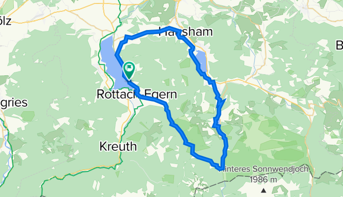
Tegernsee, Valepp, Spitzingsee, Schliersee
A cycling route starting in Tegernsee, Bavaria, Germany.
Overview
About this route
Vermutlich nette kleine Runde. Werde sie dieses Jahr einmal Probefahren, dann kann ich mehr dazu sagen für welche Fahrradtypen sie geeignet ist.
- -:--
- Duration
- 47.5 km
- Distance
- 623 m
- Ascent
- 625 m
- Descent
- ---
- Avg. speed
- ---
- Avg. speed

Route quality
Waytypes & surfaces along the route
Waytypes
Quiet road
24.6 km
(52 %)
Busy road
11.4 km
(24 %)
Surfaces
Paved
41.2 km
(87 %)
Unpaved
3.3 km
(7 %)
Asphalt
40.7 km
(86 %)
Gravel
2.1 km
(4 %)
Continue with Bikemap
Use, edit, or download this cycling route
You would like to ride Tegernsee, Valepp, Spitzingsee, Schliersee or customize it for your own trip? Here is what you can do with this Bikemap route:
Free features
- Save this route as favorite or in collections
- Copy & plan your own version of this route
- Sync your route with Garmin or Wahoo
Premium features
Free trial for 3 days, or one-time payment. More about Bikemap Premium.
- Navigate this route on iOS & Android
- Export a GPX / KML file of this route
- Create your custom printout (try it for free)
- Download this route for offline navigation
Discover more Premium features.
Get Bikemap PremiumFrom our community
Other popular routes starting in Tegernsee
 Tegernsee-zum-Schliersee
- Distance
- 11.6 km
- Ascent
- 659 m
- Descent
- 637 m
- Location
- Tegernsee, Bavaria, Germany
 Tegernsee-Valepp-Spitzingsattel-Schliersee-Tegernsee
- Distance
- 49.1 km
- Ascent
- 670 m
- Descent
- 673 m
- Location
- Tegernsee, Bavaria, Germany
 Bergtour am Tegernsee
- Distance
- 28.4 km
- Ascent
- 857 m
- Descent
- 858 m
- Location
- Tegernsee, Bavaria, Germany
 Seestraße 10, Tegernsee nach Schönwerthstraße 20–42, München
- Distance
- 49.9 km
- Ascent
- 302 m
- Descent
- 484 m
- Location
- Tegernsee, Bavaria, Germany
 Alpbachtal und Kühzagl von Tegernsee
- Distance
- 26.6 km
- Ascent
- 813 m
- Descent
- 813 m
- Location
- Tegernsee, Bavaria, Germany
 Gindelalm
- Distance
- 11.8 km
- Ascent
- 635 m
- Descent
- 637 m
- Location
- Tegernsee, Bavaria, Germany
 22.6. Tegernsee - Maurach
- Distance
- 51.4 km
- Ascent
- 1,168 m
- Descent
- 969 m
- Location
- Tegernsee, Bavaria, Germany
 Transalp 2008
- Distance
- 389.3 km
- Ascent
- 4,432 m
- Descent
- 5,129 m
- Location
- Tegernsee, Bavaria, Germany
Open it in the app