

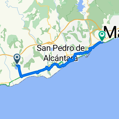
2hrs 660m 20kms Lake
A cycling route starting in Benahavís, Andalusia, Spain.
Overview
About this route
- -:--
- Duration
- 20.8 km
- Distance
- 724 m
- Ascent
- 727 m
- Descent
- ---
- Avg. speed
- ---
- Avg. speed

Continue with Bikemap
Use, edit, or download this cycling route
You would like to ride 2hrs 660m 20kms Lake or customize it for your own trip? Here is what you can do with this Bikemap route:
Free features
- Save this route as favorite or in collections
- Copy & plan your own version of this route
- Sync your route with Garmin or Wahoo
Premium features
Free trial for 3 days, or one-time payment. More about Bikemap Premium.
- Navigate this route on iOS & Android
- Export a GPX / KML file of this route
- Create your custom printout (try it for free)
- Download this route for offline navigation
Discover more Premium features.
Get Bikemap PremiumFrom our community
Other popular routes starting in Benahavís
 2hrs 660m 20kms Lake
- Distance
- 20.8 km
- Ascent
- 724 m
- Descent
- 727 m
- Location
- Benahavís, Andalusia, Spain
 5:30mins 2200m Straight up loop
- Distance
- 56.9 km
- Ascent
- 1,707 m
- Descent
- 1,721 m
- Location
- Benahavís, Andalusia, Spain
 Dymphie
- Distance
- 16.4 km
- Ascent
- 92 m
- Descent
- 115 m
- Location
- Benahavís, Andalusia, Spain
 benahavis-montemayor
- Distance
- 7.5 km
- Ascent
- 422 m
- Descent
- 420 m
- Location
- Benahavís, Andalusia, Spain
 Reservoir Trail Benahavis
- Distance
- 6.4 km
- Ascent
- 208 m
- Descent
- 209 m
- Location
- Benahavís, Andalusia, Spain
 Mirador de Igualeja 70km_1800vm
- Distance
- 69.5 km
- Ascent
- 1,520 m
- Descent
- 1,520 m
- Location
- Benahavís, Andalusia, Spain
 DAY 1 - Ronda - juzcar - smurf villages
- Distance
- 133.6 km
- Ascent
- 2,330 m
- Descent
- 2,328 m
- Location
- Benahavís, Andalusia, Spain
 Ronda 122km_2800vm
- Distance
- 121.9 km
- Ascent
- 1,775 m
- Descent
- 1,775 m
- Location
- Benahavís, Andalusia, Spain
Open it in the app