

Augustusburg, mit Rodelbahn naufzu
A cycling route starting in Zschopau, Saxony, Germany.
Overview
About this route
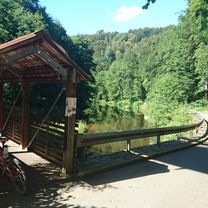
Hofrunde neu, Richtung Zschopenthal geht es an die Zschopau, vor dem Bahnübergang wird nach links abgebogen und einem schmaler trail nach Witschdorf gefolgt. Über die Brücke und dem Fußweg zur Waldstraße folgend mit der Rodelbahn - naufzu
- -:--
- Duration
- 28.9 km
- Distance
- 555 m
- Ascent
- 555 m
- Descent
- ---
- Avg. speed
- ---
- Avg. speed

Continue with Bikemap
Use, edit, or download this cycling route
You would like to ride Augustusburg, mit Rodelbahn naufzu or customize it for your own trip? Here is what you can do with this Bikemap route:
Free features
- Save this route as favorite or in collections
- Copy & plan your own version of this route
- Sync your route with Garmin or Wahoo
Premium features
Free trial for 3 days, or one-time payment. More about Bikemap Premium.
- Navigate this route on iOS & Android
- Export a GPX / KML file of this route
- Create your custom printout (try it for free)
- Download this route for offline navigation
Discover more Premium features.
Get Bikemap PremiumFrom our community
Other popular routes starting in Zschopau
 Lange Radrunde durch das Zschopautal
- Distance
- 54.2 km
- Ascent
- 617 m
- Descent
- 725 m
- Location
- Zschopau, Saxony, Germany
 Lengefeld Flöhatal Grühnhainichen
- Distance
- 40.6 km
- Ascent
- 675 m
- Descent
- 675 m
- Location
- Zschopau, Saxony, Germany
 Kurze Radrunde durch Grünhainichen
- Distance
- 10 km
- Ascent
- 309 m
- Descent
- 300 m
- Location
- Zschopau, Saxony, Germany
 Augustusburg durchs Zschopautal zurück über Spitzberg
- Distance
- 31.1 km
- Ascent
- 624 m
- Descent
- 631 m
- Location
- Zschopau, Saxony, Germany
 zum Hetzdorfer Viadukt und zurück
- Distance
- 39.5 km
- Ascent
- 986 m
- Descent
- 980 m
- Location
- Zschopau, Saxony, Germany
 local trails mit Olli
- Distance
- 24.8 km
- Ascent
- 832 m
- Descent
- 858 m
- Location
- Zschopau, Saxony, Germany
 durchs Willischtal zum Geyrischen Teich
- Distance
- 50.9 km
- Ascent
- 458 m
- Descent
- 454 m
- Location
- Zschopau, Saxony, Germany
 Rundweg Zschopau
- Distance
- 18.9 km
- Ascent
- 309 m
- Descent
- 389 m
- Location
- Zschopau, Saxony, Germany
Open it in the app