

Małopolska - Podkarpacie - Świętokrzyskie; 2017.08
A cycling route starting in Bochnia, Lesser Poland Voivodeship, Poland.
Overview
About this route
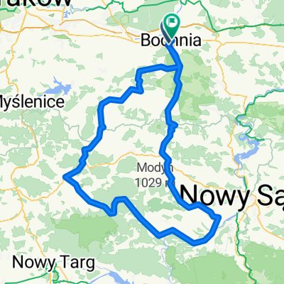
Małopolska - Podkarpacie - Świętokrzyskie; 2017.08
- -:--
- Duration
- 366.6 km
- Distance
- 551 m
- Ascent
- 545 m
- Descent
- ---
- Avg. speed
- ---
- Avg. speed

Route quality
Waytypes & surfaces along the route
Waytypes
Quiet road
147.1 km
(40 %)
Road
124.3 km
(34 %)
Surfaces
Paved
249.4 km
(68 %)
Unpaved
11.1 km
(3 %)
Asphalt
243 km
(66 %)
Gravel
5.9 km
(2 %)
Continue with Bikemap
Use, edit, or download this cycling route
You would like to ride Małopolska - Podkarpacie - Świętokrzyskie; 2017.08 or customize it for your own trip? Here is what you can do with this Bikemap route:
Free features
- Save this route as favorite or in collections
- Copy & plan your own version of this route
- Sync your route with Garmin or Wahoo
Premium features
Free trial for 3 days, or one-time payment. More about Bikemap Premium.
- Navigate this route on iOS & Android
- Export a GPX / KML file of this route
- Create your custom printout (try it for free)
- Download this route for offline navigation
Discover more Premium features.
Get Bikemap PremiumFrom our community
Other popular routes starting in Bochnia
 Brzeźnica Bochnia
- Distance
- 22.6 km
- Ascent
- 428 m
- Descent
- 424 m
- Location
- Bochnia, Lesser Poland Voivodeship, Poland
 Puszcza 47km
- Distance
- 47.2 km
- Ascent
- 106 m
- Descent
- 120 m
- Location
- Bochnia, Lesser Poland Voivodeship, Poland
 Małopolskie gminobranie
- Distance
- 361.4 km
- Ascent
- 679 m
- Descent
- 641 m
- Location
- Bochnia, Lesser Poland Voivodeship, Poland
 Laskowa i okolice
- Distance
- 96.7 km
- Ascent
- 954 m
- Descent
- 917 m
- Location
- Bochnia, Lesser Poland Voivodeship, Poland
 Bochnia - przeł. OSTRA
- Distance
- 48.4 km
- Ascent
- 972 m
- Descent
- 380 m
- Location
- Bochnia, Lesser Poland Voivodeship, Poland
 Limanowa - Łącko - Kasina Wlk. z Bochni
- Distance
- 175.2 km
- Ascent
- 1,458 m
- Descent
- 1,473 m
- Location
- Bochnia, Lesser Poland Voivodeship, Poland
 Cerkiew
- Distance
- 45.1 km
- Ascent
- 128 m
- Descent
- 112 m
- Location
- Bochnia, Lesser Poland Voivodeship, Poland
 uu22
uu22- Distance
- 56 km
- Ascent
- 1,272 m
- Descent
- 1,039 m
- Location
- Bochnia, Lesser Poland Voivodeship, Poland
Open it in the app