
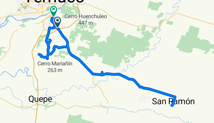
Ruta San Ramon
A cycling route starting in Temuco, Región de la Araucanía, Chile.
Overview
About this route
paientes Sra Blacksipmia, Don Santos, Don Manuel,Don Sergi Quintana, Sra Rosario, Don Erminio, Sra Teresa, Sra Maria.
- 5 h
- Duration
- 60.3 km
- Distance
- 228 m
- Ascent
- 208 m
- Descent
- 12 km/h
- Avg. speed
- ---
- Avg. speed

Route quality
Waytypes & surfaces along the route
Waytypes
Busy road
37.1 km
(61 %)
Quiet road
12.2 km
(20 %)
Surfaces
Paved
43.2 km
(72 %)
Unpaved
13.7 km
(23 %)
Asphalt
40.5 km
(67 %)
Unpaved (undefined)
13.7 km
(23 %)
Continue with Bikemap
Use, edit, or download this cycling route
You would like to ride Ruta San Ramon or customize it for your own trip? Here is what you can do with this Bikemap route:
Free features
- Save this route as favorite or in collections
- Copy & plan your own version of this route
- Sync your route with Garmin or Wahoo
Premium features
Free trial for 3 days, or one-time payment. More about Bikemap Premium.
- Navigate this route on iOS & Android
- Export a GPX / KML file of this route
- Create your custom printout (try it for free)
- Download this route for offline navigation
Discover more Premium features.
Get Bikemap PremiumFrom our community
Other popular routes starting in Temuco
 Vuelta al Cerro Mariposa
- Distance
- 25.5 km
- Ascent
- 239 m
- Descent
- 241 m
- Location
- Temuco, Región de la Araucanía, Chile
 Cerro Ñielol Asfalto
- Distance
- 3.6 km
- Ascent
- 146 m
- Descent
- 144 m
- Location
- Temuco, Región de la Araucanía, Chile
 sendero principal
- Distance
- 2.6 km
- Ascent
- 233 m
- Descent
- 61 m
- Location
- Temuco, Región de la Araucanía, Chile
 El Álamo Express
- Distance
- 30.8 km
- Ascent
- 144 m
- Descent
- 145 m
- Location
- Temuco, Región de la Araucanía, Chile
 3 Cerros
- Distance
- 67.2 km
- Ascent
- 1,369 m
- Descent
- 1,366 m
- Location
- Temuco, Región de la Araucanía, Chile
 Pumalal - Monteverde 40K
- Distance
- 37.4 km
- Ascent
- 795 m
- Descent
- 795 m
- Location
- Temuco, Región de la Araucanía, Chile
 Outdoor Sportlife Temuco - Parapente con Choripán
- Distance
- 19.6 km
- Ascent
- 315 m
- Descent
- 310 m
- Location
- Temuco, Región de la Araucanía, Chile
 Pumalal - Rucamanke 40K
- Distance
- 38.7 km
- Ascent
- 736 m
- Descent
- 739 m
- Location
- Temuco, Región de la Araucanía, Chile
Open it in the app