

Glehn - ANT 170er
A cycling route starting in Korschenbroich, North Rhine-Westphalia, Germany.
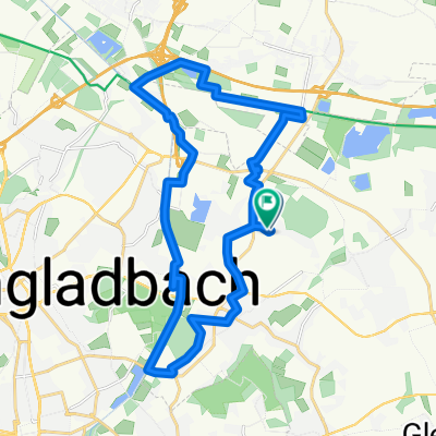
Overview
About this route
Unterhalb von Mönchegladbach-Rheydt über die Felder nach Odenkirchen. Dann gemütlich Richtung Arsbek und Vlodrop, NL. Bei Maasbracht über die Autobahnbrücke und weiter nach Kinroi, und den Kanal dahinter. Der westliche Kanal ist der Richtige ;-) Dieser Kanal führt wunderbar ruhig bis Herentals, ab da wird´s industrieller. 60 km sind es dann noch bis zum Ziel. Ab Wijnegem über die Schleuse (etwas abenteuerlich) den Kanal überqueren und hinter sich lassen und dann links runter über die langestreckte Stichstrasse bis zum Stadtpark Rivierenhof. Hier kann man herrlich ruhig in die Stadt abkürzen und rollen lassen.
- -:--
- Duration
- 171.9 km
- Distance
- 100 m
- Ascent
- 139 m
- Descent
- ---
- Avg. speed
- ---
- Avg. speed

Route quality
Waytypes & surfaces along the route
Waytypes
Access road
39.8 km
(23 %)
Quiet road
37.4 km
(22 %)
Surfaces
Paved
99.9 km
(58 %)
Unpaved
22.9 km
(13 %)
Asphalt
89.9 km
(52 %)
Ground
12.2 km
(7 %)
Continue with Bikemap
Use, edit, or download this cycling route
You would like to ride Glehn - ANT 170er or customize it for your own trip? Here is what you can do with this Bikemap route:
Free features
- Save this route as favorite or in collections
- Copy & plan your own version of this route
- Sync your route with Garmin or Wahoo
Premium features
Free trial for 3 days, or one-time payment. More about Bikemap Premium.
- Navigate this route on iOS & Android
- Export a GPX / KML file of this route
- Create your custom printout (try it for free)
- Download this route for offline navigation
Discover more Premium features.
Get Bikemap PremiumFrom our community
Other popular routes starting in Korschenbroich
 Korschenbroich 1
- Distance
- 23.7 km
- Ascent
- 31 m
- Descent
- 28 m
- Location
- Korschenbroich, North Rhine-Westphalia, Germany
 gr. Runde
- Distance
- 9.9 km
- Ascent
- 43 m
- Descent
- 43 m
- Location
- Korschenbroich, North Rhine-Westphalia, Germany
 Am alten Brauhaus, Rundtour am Nordkanal und an der Niers
- Distance
- 23.8 km
- Ascent
- 25 m
- Descent
- 24 m
- Location
- Korschenbroich, North Rhine-Westphalia, Germany
 Grenzerfahrung Mönchengladbach
- Distance
- 85.1 km
- Ascent
- 130 m
- Descent
- 128 m
- Location
- Korschenbroich, North Rhine-Westphalia, Germany
 Route 007 (KB-Glehn-SchlossDyck-KB)
- Distance
- 26.8 km
- Ascent
- 38 m
- Descent
- 41 m
- Location
- Korschenbroich, North Rhine-Westphalia, Germany
 Kaarst-Niers 20
- Distance
- 20.9 km
- Ascent
- 23 m
- Descent
- 24 m
- Location
- Korschenbroich, North Rhine-Westphalia, Germany
 Von Schloss zu Schloss in Mönchengladbachs Osten
- Distance
- 36.5 km
- Ascent
- 330 m
- Descent
- 379 m
- Location
- Korschenbroich, North Rhine-Westphalia, Germany
 ALT-79-NRET-2025-MG-Korschenbroich-Kaarst-MG
- Distance
- 29.8 km
- Ascent
- 23 m
- Descent
- 26 m
- Location
- Korschenbroich, North Rhine-Westphalia, Germany
Open it in the app