

St. Zyprian - Schlernhaus - Seis
A cycling route starting in Tiers, Trentino-Alto Adige, Italy.
Overview
About this route
Mit Bus Linie 176 um 09:06 Uhr ab Seis nach St. Zyprian
- -:--
- Duration
- 16.3 km
- Distance
- 1,481 m
- Ascent
- 1,493 m
- Descent
- ---
- Avg. speed
- ---
- Avg. speed

Continue with Bikemap
Use, edit, or download this cycling route
You would like to ride St. Zyprian - Schlernhaus - Seis or customize it for your own trip? Here is what you can do with this Bikemap route:
Free features
- Save this route as favorite or in collections
- Copy & plan your own version of this route
- Sync your route with Garmin or Wahoo
Premium features
Free trial for 3 days, or one-time payment. More about Bikemap Premium.
- Navigate this route on iOS & Android
- Export a GPX / KML file of this route
- Create your custom printout (try it for free)
- Download this route for offline navigation
Discover more Premium features.
Get Bikemap PremiumFrom our community
Other popular routes starting in Tiers
 Nigerpass / Rosengarten-Latemar
- Distance
- 32.7 km
- Ascent
- 1,110 m
- Descent
- 1,110 m
- Location
- Tiers, Trentino-Alto Adige, Italy
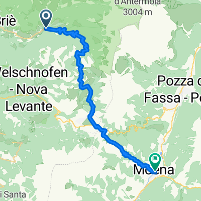 St. Zyprian Moena
- Distance
- 22.4 km
- Ascent
- 740 m
- Descent
- 648 m
- Location
- Tiers, Trentino-Alto Adige, Italy
 bergamo
- Distance
- 15.1 km
- Ascent
- 1,628 m
- Descent
- 836 m
- Location
- Tiers, Trentino-Alto Adige, Italy
 07 - Nova Levante_Welschnofen-Obergummer_Gummer(San Valentino) - Nova Levante/Welschnofen-Obergummer/Gummer(San Valentino)
- Distance
- 49.6 km
- Ascent
- 2,049 m
- Descent
- 2,046 m
- Location
- Tiers, Trentino-Alto Adige, Italy
 Santa Kathrein 28, Völs am Schlern nach Weingartnerweg, Völs am Schlern
- Distance
- 7.3 km
- Ascent
- 180 m
- Descent
- 495 m
- Location
- Tiers, Trentino-Alto Adige, Italy
 Catinaccio
- Distance
- 38 km
- Ascent
- 1,888 m
- Descent
- 1,889 m
- Location
- Tiers, Trentino-Alto Adige, Italy
 Tierser Runde
- Distance
- 11.4 km
- Ascent
- 738 m
- Descent
- 123 m
- Location
- Tiers, Trentino-Alto Adige, Italy
 AlpenX 2020 Teil2
- Distance
- 255 km
- Ascent
- 6,297 m
- Descent
- 7,248 m
- Location
- Tiers, Trentino-Alto Adige, Italy
Open it in the app