

Chesbro longer ride
A cycling route starting in Agoura, California, United States of America.
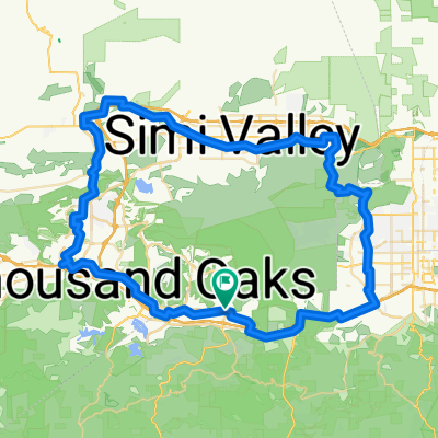
Overview
About this route
lower ridge tres amigos palo lookout sheps gas line bell canyon ho chi min pump hill to parking lot
- -:--
- Duration
- 24.2 km
- Distance
- 527 m
- Ascent
- 527 m
- Descent
- ---
- Avg. speed
- ---
- Avg. speed

Route quality
Waytypes & surfaces along the route
Waytypes
Path
18.7 km
(77 %)
Track
5.3 km
(22 %)
Surfaces
Paved
0 km
(<1 %)
Unpaved
11.2 km
(46 %)
Unpaved (undefined)
6.4 km
(27 %)
Ground
4.8 km
(20 %)
Continue with Bikemap
Use, edit, or download this cycling route
You would like to ride Chesbro longer ride or customize it for your own trip? Here is what you can do with this Bikemap route:
Free features
- Save this route as favorite or in collections
- Copy & plan your own version of this route
- Sync your route with Garmin or Wahoo
Premium features
Free trial for 3 days, or one-time payment. More about Bikemap Premium.
- Navigate this route on iOS & Android
- Export a GPX / KML file of this route
- Create your custom printout (try it for free)
- Download this route for offline navigation
Discover more Premium features.
Get Bikemap PremiumFrom our community
Other popular routes starting in Agoura
 Cheseboro Canyon
- Distance
- 14.9 km
- Ascent
- 243 m
- Descent
- 244 m
- Location
- Agoura, California, United States of America
 Westlake Loop Route 30 mile ride
- Distance
- 52.2 km
- Ascent
- 672 m
- Descent
- 671 m
- Location
- Agoura, California, United States of America
 To Pedalers Fork from Agoura Hills1
- Distance
- 44.6 km
- Ascent
- 459 m
- Descent
- 456 m
- Location
- Agoura, California, United States of America
 Santa Suzana Mtn's loop
- Distance
- 89.1 km
- Ascent
- 777 m
- Descent
- 777 m
- Location
- Agoura, California, United States of America
 Stunt Piuma loop
- Distance
- 61.2 km
- Ascent
- 1,002 m
- Descent
- 999 m
- Location
- Agoura, California, United States of America
 agoura to hidden hills
- Distance
- 9.3 km
- Ascent
- 240 m
- Descent
- 209 m
- Location
- Agoura, California, United States of America
 Latigo Piccolo
- Distance
- 54.6 km
- Ascent
- 920 m
- Descent
- 920 m
- Location
- Agoura, California, United States of America
 To Albertson's motorway and gas pipe
- Distance
- 28.9 km
- Ascent
- 663 m
- Descent
- 663 m
- Location
- Agoura, California, United States of America
Open it in the app