Premium Badge Download on the App Store Get it on Google Play Turn-by-turn Navigation Offline Maps Bike Type Optimized Routing Premium Maps Custom Bike Computer Export Routes Route Previews Fall Detection Premium Support

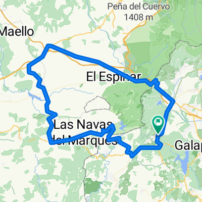
Cycling Route in El Escorial, Madrid, Spain

San Lorenzo-Peguerinos-Santa Maria-S.L.

1
Open this route in the Bikemap app

Open this route in the Bikemap app

Open this route in Bikemap Web

Open this route in Bikemap Web

52 km
Distance
1166 m
Ascent
1168 m
Descent
-:-- h
Duration
-- km/h
Avg. Speed
--- m
Max. Elevation

About This Route

Recorrido circular desde San Lorenzo de El Escorial, pasando por Embalse Ace帽a, Peguerinos, RIo Cofio, Santa Maria La Estaci贸n, La Hoya, Puerto Cruz Verde y finalizando en San Lorenzo.

Recorrido mixto. Aproximadamente el 60% del recorrido es por asfalto, pero el resto es por pista irregular, en muchos tramos dif铆cil de recorrer con arenales, piedras, grava suelta, rodales, ramas, etc.

This cycling route is ideal for: MTB

You will cycle on the following surfaces: Paved Gravel

Customize this cycling route with the Bikemap route planner.

Make it yours!

Did you know? You can use this route as a template in our cycling route planner if you don't wish to start from scratch. Customize it based on your needs to plan your perfect cycling tour.

Open it in the app