

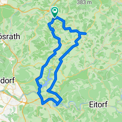
von Aggertal zum Allnersee
A cycling route starting in Overath, North Rhine-Westphalia, Germany.
Overview
About this route
Der Agger-Radweg lädt zum Radeln mit der ganzen Familie ein – ob am Wasser, entlang von flachen Auenlandschaften oder im Wald. Schwingen Sie sich aufs Rad und erfahren die landschaftliche Vielfalt der attraktiven Kulturlandschaft in den Flusstälern von Agger.
- -:--
- Duration
- 51.3 km
- Distance
- 99 m
- Ascent
- 127 m
- Descent
- ---
- Avg. speed
- ---
- Avg. speed

Route quality
Waytypes & surfaces along the route
Waytypes
Path
26.4 km
(52 %)
Quiet road
12.3 km
(24 %)
Surfaces
Paved
43.9 km
(86 %)
Unpaved
5.2 km
(10 %)
Asphalt
41.3 km
(81 %)
Loose gravel
3 km
(6 %)
Continue with Bikemap
Use, edit, or download this cycling route
You would like to ride von Aggertal zum Allnersee or customize it for your own trip? Here is what you can do with this Bikemap route:
Free features
- Save this route as favorite or in collections
- Copy & plan your own version of this route
- Sync your route with Garmin or Wahoo
Premium features
Free trial for 3 days, or one-time payment. More about Bikemap Premium.
- Navigate this route on iOS & Android
- Export a GPX / KML file of this route
- Create your custom printout (try it for free)
- Download this route for offline navigation
Discover more Premium features.
Get Bikemap PremiumFrom our community
Other popular routes starting in Overath
 Immekeppeler Runde 18 km
- Distance
- 18.1 km
- Ascent
- 499 m
- Descent
- 506 m
- Location
- Overath, North Rhine-Westphalia, Germany
 Täler und Höhen Seelscheid (RTF)
- Distance
- 109.5 km
- Ascent
- 1,245 m
- Descent
- 1,222 m
- Location
- Overath, North Rhine-Westphalia, Germany
 von Overath nach Verr/Drabenderhöhe
- Distance
- 31.8 km
- Ascent
- 403 m
- Descent
- 403 m
- Location
- Overath, North Rhine-Westphalia, Germany
 Schnelle Radrunde durch Lohmar
- Distance
- 3.5 km
- Ascent
- 43 m
- Descent
- 141 m
- Location
- Overath, North Rhine-Westphalia, Germany
 Route zu Altenheim Marialinden
- Distance
- 62.7 km
- Ascent
- 997 m
- Descent
- 995 m
- Location
- Overath, North Rhine-Westphalia, Germany
 Overath-Biesfeld-Lindlar
- Distance
- 54.8 km
- Ascent
- 829 m
- Descent
- 813 m
- Location
- Overath, North Rhine-Westphalia, Germany
 RTF Seelscheid, 151 km
- Distance
- 145.8 km
- Ascent
- 1,033 m
- Descent
- 1,031 m
- Location
- Overath, North Rhine-Westphalia, Germany
 Talstrasse - Wahn-Heide
- Distance
- 27.9 km
- Ascent
- 556 m
- Descent
- 547 m
- Location
- Overath, North Rhine-Westphalia, Germany
Open it in the app