

dg Corona dei Pinci Bike
A cycling route starting in Losone, Canton Ticino, Switzerland.
Overview
About this route
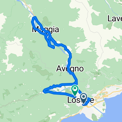
Vom Ortszentrum in Losone führt die Strecke über die Strasse hinauf auf den Monte Verità, der aufgrund seines historischen und kulturellen Erbes auch Berg der Wahrheit genannt wird. Beim nächsten Streckenabschnitt geht es über rund 1000 Meter hinauf auf den Monte Sassello, von wo aus man einen herrlichen Panoramablick auf die gesamte Region des Lago Maggiore geniesst. Die erste Hälfte der Talfahrt verläuft dann flach und mühelos durch einen dichten Buchenwald in Richtung der Alphütte Alpe Zot. Von hier aus führt die Strecke weiter bergab und durch die umliegenden Kastanienwälder in Richtung Artore. Nachdem man Artore passiert hat, wird die Strecke wieder anspruchsvoller und führt über einen steinigen Pfad mit herausfordernden Serpentinen weiter in das bezaubernde Dorf Arcegno mit seinen Steinhäusern. Nach der Durchfahrt dieses kleinen Ortes sind es rund 3 Kilometer zurück zum Ausgangspunkt Losone.
- -:--
- Duration
- 22.3 km
- Distance
- 1,073 m
- Ascent
- 1,071 m
- Descent
- ---
- Avg. speed
- ---
- Avg. speed

Continue with Bikemap
Use, edit, or download this cycling route
You would like to ride dg Corona dei Pinci Bike or customize it for your own trip? Here is what you can do with this Bikemap route:
Free features
- Save this route as favorite or in collections
- Copy & plan your own version of this route
- Sync your route with Garmin or Wahoo
Premium features
Free trial for 3 days, or one-time payment. More about Bikemap Premium.
- Navigate this route on iOS & Android
- Export a GPX / KML file of this route
- Create your custom printout (try it for free)
- Download this route for offline navigation
Discover more Premium features.
Get Bikemap PremiumFrom our community
Other popular routes starting in Losone
 Losone Spluga
- Distance
- 50.4 km
- Ascent
- 1,076 m
- Descent
- 1,076 m
- Location
- Losone, Canton Ticino, Switzerland
 Route des Polonais
- Distance
- 21 km
- Ascent
- 344 m
- Descent
- 345 m
- Location
- Losone, Canton Ticino, Switzerland
 dintorni bassa Vallemaggia
- Distance
- 40.2 km
- Ascent
- 286 m
- Descent
- 268 m
- Location
- Losone, Canton Ticino, Switzerland
 Trail Pardo
- Distance
- 13.5 km
- Ascent
- 780 m
- Descent
- 862 m
- Location
- Losone, Canton Ticino, Switzerland
 Losone - Golino - Foce Maggia - Losone
- Distance
- 24.6 km
- Ascent
- 105 m
- Descent
- 105 m
- Location
- Losone, Canton Ticino, Switzerland
 losone-brissago strada alta #celafarò#
- Distance
- 12.2 km
- Ascent
- 519 m
- Descent
- 549 m
- Location
- Losone, Canton Ticino, Switzerland
 Terre di Pedemonte e Locarno
- Distance
- 26.5 km
- Ascent
- 184 m
- Descent
- 186 m
- Location
- Losone, Canton Ticino, Switzerland
 Giro a velocità costante in
- Distance
- 22.5 km
- Ascent
- 308 m
- Descent
- 265 m
- Location
- Losone, Canton Ticino, Switzerland
Open it in the app