

MTB Anninger 1000hm
A cycling route starting in Traiskirchen, Lower Austria, Austria.
Overview
About this route
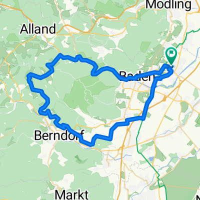
MTB Route: Pfaffstätten-Waldandacht-Veiglhütte-Wilhelmswarte (höchster Punkt)-Anningerhaus-Husarentempel-Breite Föhre-Krauste Linde-Anningerhaus-Prockschhütte (Klesheimwarte)-Pfaffstätten.
lt. Garmin 1008 Höhenmeter, ca.33km
In der Tour sind die wichtigsten "Sehenswürdigkeiten" vom Anninger enthalten :)
- -:--
- Duration
- 32.7 km
- Distance
- 905 m
- Ascent
- 905 m
- Descent
- ---
- Avg. speed
- ---
- Avg. speed

Continue with Bikemap
Use, edit, or download this cycling route
You would like to ride MTB Anninger 1000hm or customize it for your own trip? Here is what you can do with this Bikemap route:
Free features
- Save this route as favorite or in collections
- Copy & plan your own version of this route
- Sync your route with Garmin or Wahoo
Premium features
Free trial for 3 days, or one-time payment. More about Bikemap Premium.
- Navigate this route on iOS & Android
- Export a GPX / KML file of this route
- Create your custom printout (try it for free)
- Download this route for offline navigation
Discover more Premium features.
Get Bikemap PremiumFrom our community
Other popular routes starting in Traiskirchen
 TK Oberlaa Schwechat TK
- Distance
- 55 km
- Ascent
- 107 m
- Descent
- 105 m
- Location
- Traiskirchen, Lower Austria, Austria
 Traiskirchen Ebreichsdorf Traiskirchen
- Distance
- 31.9 km
- Ascent
- 41 m
- Descent
- 40 m
- Location
- Traiskirchen, Lower Austria, Austria
 MTB_Helenental_Zobelh_Triesting
- Distance
- 58.1 km
- Ascent
- 522 m
- Descent
- 521 m
- Location
- Traiskirchen, Lower Austria, Austria
 Traiskirchen _ Mariazell
- Distance
- 134 km
- Ascent
- 1,176 m
- Descent
- 510 m
- Location
- Traiskirchen, Lower Austria, Austria
 MTB_Guglzipf_2Hügel
- Distance
- 50.3 km
- Ascent
- 373 m
- Descent
- 363 m
- Location
- Traiskirchen, Lower Austria, Austria
 EV9 Kottingbrunn-Sollenau
- Distance
- 19.1 km
- Ascent
- 86 m
- Descent
- 21 m
- Location
- Traiskirchen, Lower Austria, Austria
 TR_Husarentempel
- Distance
- 13.9 km
- Ascent
- 331 m
- Descent
- 46 m
- Location
- Traiskirchen, Lower Austria, Austria
 Wien 10. - Laxenburg+
- Distance
- 44 km
- Ascent
- 116 m
- Descent
- 116 m
- Location
- Traiskirchen, Lower Austria, Austria
Open it in the app