

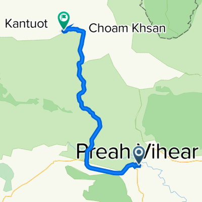
KH_Preah Vihear - Stung Treng
A cycling route starting in Tbêng Méanchey, Preah Vihear, Cambodia.
Overview
About this route
Durchs Land in Richtung Mekong
- -:--
- Duration
- 141 km
- Distance
- 215 m
- Ascent
- 213 m
- Descent
- ---
- Avg. speed
- ---
- Avg. speed
Route quality
Waytypes & surfaces along the route
Waytypes
Busy road
115.7 km
(82 %)
Quiet road
24 km
(17 %)
Surfaces
Paved
115.5 km
(82 %)
Unpaved
12.9 km
(9 %)
Asphalt
105.1 km
(75 %)
Unpaved (undefined)
12.9 km
(9 %)
Continue with Bikemap
Use, edit, or download this cycling route
You would like to ride KH_Preah Vihear - Stung Treng or customize it for your own trip? Here is what you can do with this Bikemap route:
Free features
- Save this route as favorite or in collections
- Copy & plan your own version of this route
- Sync your route with Garmin or Wahoo
Premium features
Free trial for 3 days, or one-time payment. More about Bikemap Premium.
- Navigate this route on iOS & Android
- Export a GPX / KML file of this route
- Create your custom printout (try it for free)
- Download this route for offline navigation
Discover more Premium features.
Get Bikemap PremiumFrom our community
Other popular routes starting in Tbêng Méanchey
 RX2H+RM7, ក្រុងព្រះវិហារ to ផ្លូវលេខ អា១៦, ក្រុងព្រះវិហារ
- Distance
- 4.1 km
- Ascent
- 75 m
- Descent
- 71 m
- Location
- Tbêng Méanchey, Preah Vihear, Cambodia
 3) Preah Vihear - Kaoh Ker temples
- Distance
- 75.9 km
- Ascent
- 209 m
- Descent
- 123 m
- Location
- Tbêng Méanchey, Preah Vihear, Cambodia
 J024 - dimanche 01 février 2015 - Preah Vihear - Chhep Kandal ( Shaeb )
- Distance
- 55.6 km
- Ascent
- 134 m
- Descent
- 106 m
- Location
- Tbêng Méanchey, Preah Vihear, Cambodia
 RX2H+RM7, ក្រុងព្រះវិហារ to RX2H+RM7, ក្រុងព្រះវិហារ
- Distance
- 5.2 km
- Ascent
- 47 m
- Descent
- 47 m
- Location
- Tbêng Méanchey, Preah Vihear, Cambodia
 J023 – Samedi 28 janvier 2017 Preah Vihear – Sra Aem
- Distance
- 86.2 km
- Ascent
- 110 m
- Descent
- 86 m
- Location
- Tbêng Méanchey, Preah Vihear, Cambodia
 Preah Vihear - Stung Treng 139 km
- Distance
- 139 km
- Ascent
- 230 m
- Descent
- 234 m
- Location
- Tbêng Méanchey, Preah Vihear, Cambodia
 KH_Preah Vihear - Stung Treng
- Distance
- 141 km
- Ascent
- 215 m
- Descent
- 213 m
- Location
- Tbêng Méanchey, Preah Vihear, Cambodia
 RX2H+RM7, ក្រុងព្រះវិហារ to RX2H+RM7, ក្រុងព្រះវិហារ
- Distance
- 6.2 km
- Ascent
- 81 m
- Descent
- 77 m
- Location
- Tbêng Méanchey, Preah Vihear, Cambodia
Open it in the app