

Route des crêtes 7bis (Crozet-St Cergue)
A cycling route starting in Geneva, Canton of Geneva, Switzerland.
Overview
About this route
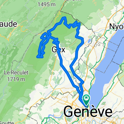
Parcours VTT alternatif à ma Route des crêtes 7 : Flies-Crozet hors trafic, puis retour par Trélex, Divonne et Meyrin, plutôt que Nyon et la Route de Suisse.
Distance : 116 km
Dénivelé positif : 1670 m
Altitude maximale : 1520 m (piste d'alpage de la Maréchaude)
Plus d'informations sur www.europebybike.info
- -:--
- Duration
- 116.4 km
- Distance
- 1,487 m
- Ascent
- 1,484 m
- Descent
- ---
- Avg. speed
- ---
- Avg. speed

Route highlights
Points of interest along the route
Point of interest after 13.7 km
Fontaine d'eau potable
Point of interest after 44.4 km
Col de la Faucille : cafés et restaurants (pas toujours ouverts)
Point of interest after 52.6 km
Chalet de la Grande Grand et combe magique...
Point of interest after 57.7 km
Café-restaurant de Cuvaloup-de-Crans
Point of interest after 64.3 km
St-Cergue : commerces et cafés
Continue with Bikemap
Use, edit, or download this cycling route
You would like to ride Route des crêtes 7bis (Crozet-St Cergue) or customize it for your own trip? Here is what you can do with this Bikemap route:
Free features
- Save this route as favorite or in collections
- Copy & plan your own version of this route
- Sync your route with Garmin or Wahoo
Premium features
Free trial for 3 days, or one-time payment. More about Bikemap Premium.
- Navigate this route on iOS & Android
- Export a GPX / KML file of this route
- Create your custom printout (try it for free)
- Download this route for offline navigation
Discover more Premium features.
Get Bikemap PremiumFrom our community
Other popular routes starting in Geneva
 Pas de l'Echine
- Distance
- 84.8 km
- Ascent
- 1,707 m
- Descent
- 1,705 m
- Location
- Geneva, Canton of Geneva, Switzerland
 Backside of the Jura, over Faucille, Marchairuz
- Distance
- 139 km
- Ascent
- 2,635 m
- Descent
- 2,595 m
- Location
- Geneva, Canton of Geneva, Switzerland
 25.11 WePerf
- Distance
- 72.5 km
- Ascent
- 380 m
- Descent
- 370 m
- Location
- Geneva, Canton of Geneva, Switzerland
 J.6.Genf - Lyon Zentrum
- Distance
- 195.8 km
- Ascent
- 1,023 m
- Descent
- 1,174 m
- Location
- Geneva, Canton of Geneva, Switzerland
 Vallée Verte Col Hunting
- Distance
- 92.6 km
- Ascent
- 1,629 m
- Descent
- 1,577 m
- Location
- Geneva, Canton of Geneva, Switzerland
 Bords du Rhône (Petit Parcours)
- Distance
- 35.6 km
- Ascent
- 417 m
- Descent
- 417 m
- Location
- Geneva, Canton of Geneva, Switzerland
 Day 1 Geneva to La Clusaz
- Distance
- 105.8 km
- Ascent
- 2,193 m
- Descent
- 1,533 m
- Location
- Geneva, Canton of Geneva, Switzerland
 Loop Gva-Vesancy-Vesancy-Gex-Malval
- Distance
- 77.6 km
- Ascent
- 1,029 m
- Descent
- 998 m
- Location
- Geneva, Canton of Geneva, Switzerland
Open it in the app