

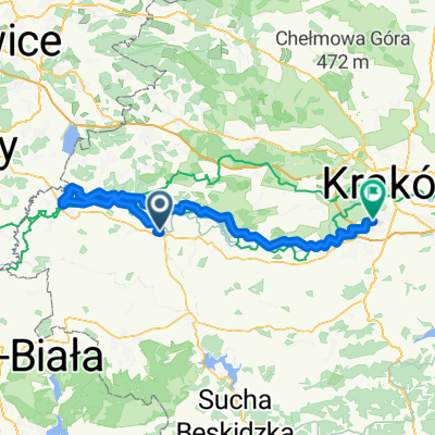
ROWEROWY SZLAK DOLINY KARPIA
A cycling route starting in Zator, Lesser Poland Voivodeship, Poland.
Overview
About this route
- -:--
- Duration
- 88.9 km
- Distance
- 313 m
- Ascent
- 314 m
- Descent
- ---
- Avg. speed
- ---
- Avg. speed

Route quality
Waytypes & surfaces along the route
Waytypes
Quiet road
48.2 km
(54 %)
Road
35.3 km
(40 %)
Surfaces
Paved
77 km
(87 %)
Unpaved
4.1 km
(5 %)
Asphalt
76.5 km
(86 %)
Ground
2 km
(2 %)
Continue with Bikemap
Use, edit, or download this cycling route
You would like to ride ROWEROWY SZLAK DOLINY KARPIA or customize it for your own trip? Here is what you can do with this Bikemap route:
Free features
- Save this route as favorite or in collections
- Copy & plan your own version of this route
- Sync your route with Garmin or Wahoo
Premium features
Free trial for 3 days, or one-time payment. More about Bikemap Premium.
- Navigate this route on iOS & Android
- Export a GPX / KML file of this route
- Create your custom printout (try it for free)
- Download this route for offline navigation
Discover more Premium features.
Get Bikemap PremiumFrom our community
Other popular routes starting in Zator
 Trasa 3 (miniB) - Poranny śpiew ptasiej grobli (B)
- Distance
- 16.6 km
- Ascent
- 35 m
- Descent
- 36 m
- Location
- Zator, Lesser Poland Voivodeship, Poland
 Cycle Poland 2013: day 2
- Distance
- 122.9 km
- Ascent
- 526 m
- Descent
- 481 m
- Location
- Zator, Lesser Poland Voivodeship, Poland
 Zator - Oswiecim - Rajsko - Osiek - Zator
- Distance
- 53.5 km
- Ascent
- 114 m
- Descent
- 111 m
- Location
- Zator, Lesser Poland Voivodeship, Poland
 Zator i okolice
- Distance
- 47.6 km
- Ascent
- 500 m
- Descent
- 499 m
- Location
- Zator, Lesser Poland Voivodeship, Poland
 Dolina Karpia - Pętla
- Distance
- 40.2 km
- Ascent
- 54 m
- Descent
- 52 m
- Location
- Zator, Lesser Poland Voivodeship, Poland
 Wiślana Trasa Rowerowa - Małopolska
- Distance
- 47.8 km
- Ascent
- 41 m
- Descent
- 34 m
- Location
- Zator, Lesser Poland Voivodeship, Poland
 Zator PKP_Oświęcim_Krk_Czerwone Maki
- Distance
- 87.5 km
- Ascent
- 139 m
- Descent
- 141 m
- Location
- Zator, Lesser Poland Voivodeship, Poland
 Pętla_wokol_Zatora
- Distance
- 40.7 km
- Ascent
- 52 m
- Descent
- 52 m
- Location
- Zator, Lesser Poland Voivodeship, Poland
Open it in the app