

41 km 1
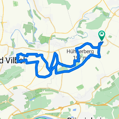
A cycling route starting in Niederdorfelden, Hesse, Germany.
Overview
About this route
Diese Radroute führt auf vorwiegend asphaltiertem Untergrund sie
NIEDERDORFELDEN
OBERDORFELDEN
KILIANSTÄDTEN
BÜDESHEIM - K853
NIDDERAU - B521
EICHEN- B521 Radweg
HÖCHST - K232
ROMMELHAUSEN - L3189
KONTROLLE
OSTHEIM L3347
WINDECKEN -L3009
HOHE STRAßE
OBERDORFELDEN
NIEDERDORFELDEN
Die Kontrolle befindet sich in Rommelhausen
Richtung Ostheim in einer Nebenstraße
- -:--
- Duration
- 39.5 km
- Distance
- 147 m
- Ascent
- 147 m
- Descent
- ---
- Avg. speed
- ---
- Avg. speed

Route quality
Waytypes & surfaces along the route
Waytypes
Busy road
13.9 km
(35 %)
Road
8.6 km
(22 %)
Surfaces
Paved
39.3 km
(99 %)
Asphalt
36.3 km
(92 %)
Paving stones
3 km
(8 %)
Continue with Bikemap
Use, edit, or download this cycling route
You would like to ride 41 km 1 or customize it for your own trip? Here is what you can do with this Bikemap route:
Free features
- Save this route as favorite or in collections
- Copy & plan your own version of this route
- Sync your route with Garmin or Wahoo
Premium features
Free trial for 3 days, or one-time payment. More about Bikemap Premium.
- Navigate this route on iOS & Android
- Export a GPX / KML file of this route
- Create your custom printout (try it for free)
- Download this route for offline navigation
Discover more Premium features.
Get Bikemap PremiumFrom our community
Other popular routes starting in Niederdorfelden
 Herbsttour 46km Niederdorfelden
- Distance
- 55.2 km
- Ascent
- 333 m
- Descent
- 248 m
- Location
- Niederdorfelden, Hesse, Germany
 Klosterrunde
- Distance
- 43.5 km
- Ascent
- 375 m
- Descent
- 376 m
- Location
- Niederdorfelden, Hesse, Germany
 Schoeneck-Nidda Loop
- Distance
- 97.7 km
- Ascent
- 855 m
- Descent
- 851 m
- Location
- Niederdorfelden, Hesse, Germany
 Herbst Tour 2010 115km
- Distance
- 118.4 km
- Ascent
- 844 m
- Descent
- 815 m
- Location
- Niederdorfelden, Hesse, Germany
 RTF Niederdorfelden am 11.10.2009
- Distance
- 113.5 km
- Ascent
- 946 m
- Descent
- 923 m
- Location
- Niederdorfelden, Hesse, Germany
 Home-Loop 3: Wilhelmsbad - Hochstadt - Wachenbuchen
- Distance
- 23.4 km
- Ascent
- 182 m
- Descent
- 182 m
- Location
- Niederdorfelden, Hesse, Germany
 Hausroute
- Distance
- 25.8 km
- Ascent
- 147 m
- Descent
- 148 m
- Location
- Niederdorfelden, Hesse, Germany
 Home-Loop 2: Hohe Straße - Niederdorfelden - Bad Vilbel - zurück
- Distance
- 26.7 km
- Ascent
- 264 m
- Descent
- 264 m
- Location
- Niederdorfelden, Hesse, Germany
Open it in the app