

Ruta10La Garriga
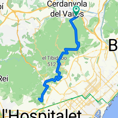
A cycling route starting in Cerdanyola del Vallès, Catalonia, Spain.
Overview
About this route
Itinerari que ens portarà fins a la Garriga passant per La Roca, Llinars del Vallès i Sant Antoni de Vilamajor fins arribar a Cànoves, on afrontarem una petita pujada en la que haurem d'esforçar-nos una mica més. Baixarem fins La Garriga per tornar a casa per les poblacions conegudes d'altres rutes, com Bigues, Lliça i Polinyà. En definitiva una volta circular, sense massa desnivell que ens permetrà rodar bastant ràpid i conèixer una mica la geografia de la comarca del Vallès Oriental.
PROMIG TEMPS A 32km/h2h45m 30km/h2h56m 28km/h3h08m
- -:--
- Duration
- 87.5 km
- Distance
- 521 m
- Ascent
- 543 m
- Descent
- ---
- Avg. speed
- ---
- Avg. speed

Route quality
Waytypes & surfaces along the route
Waytypes
Road
54.4 km
(62 %)
Busy road
19.3 km
(22 %)
Surfaces
Paved
47.2 km
(54 %)
Asphalt
46.7 km
(53 %)
Paved (undefined)
0.4 km
(<1 %)
Continue with Bikemap
Use, edit, or download this cycling route
You would like to ride Ruta10La Garriga or customize it for your own trip? Here is what you can do with this Bikemap route:
Free features
- Save this route as favorite or in collections
- Copy & plan your own version of this route
- Sync your route with Garmin or Wahoo
Premium features
Free trial for 3 days, or one-time payment. More about Bikemap Premium.
- Navigate this route on iOS & Android
- Export a GPX / KML file of this route
- Create your custom printout (try it for free)
- Download this route for offline navigation
Discover more Premium features.
Get Bikemap PremiumFrom our community
Other popular routes starting in Cerdanyola del Vallès
 Ruta50 Font Groga
- Distance
- 25 km
- Ascent
- 533 m
- Descent
- 534 m
- Location
- Cerdanyola del Vallès, Catalonia, Spain
 hasta barcelona
- Distance
- 11 km
- Ascent
- 269 m
- Descent
- 269 m
- Location
- Cerdanyola del Vallès, Catalonia, Spain
 Ruta51 Sant Pere Martir i tornada
- Distance
- 44.7 km
- Ascent
- 721 m
- Descent
- 726 m
- Location
- Cerdanyola del Vallès, Catalonia, Spain
 Ruta04Parpers Can Bordoi i tornada per Santa Agnès
- Distance
- 81.6 km
- Ascent
- 696 m
- Descent
- 697 m
- Location
- Cerdanyola del Vallès, Catalonia, Spain
 Ruta06Sant Feliu de Codines
- Distance
- 66.8 km
- Ascent
- 666 m
- Descent
- 664 m
- Location
- Cerdanyola del Vallès, Catalonia, Spain
 Casi para el camion de la bimbo bosque perdido - bonus cerveza
- Distance
- 16.5 km
- Ascent
- 418 m
- Descent
- 418 m
- Location
- Cerdanyola del Vallès, Catalonia, Spain
 Ruta02 Volta per Crta. Molins.
- Distance
- 43.6 km
- Ascent
- 687 m
- Descent
- 679 m
- Location
- Cerdanyola del Vallès, Catalonia, Spain
 Ruta14Quatre vents per Castellbisball
- Distance
- 53.3 km
- Ascent
- 505 m
- Descent
- 508 m
- Location
- Cerdanyola del Vallès, Catalonia, Spain
Open it in the app