

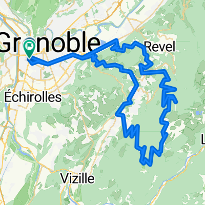
Grenoble--Eybens--Brié--Uriage-les-Bains--Venon--Gre
A cycling route starting in Grenoble, Auvergne-Rhône-Alpes, France.
Overview
About this route
Attention, la fin est un peu plus compliquée, mais à côté de l'arrêt de tram "Plaine des Sports" se trouve une piste cyclable adaptée à des vélos de ville et aux VTT, un peu moins bien aux vélos de course.
- -:--
- Duration
- 30.8 km
- Distance
- 603 m
- Ascent
- 604 m
- Descent
- ---
- Avg. speed
- ---
- Avg. speed

Continue with Bikemap
Use, edit, or download this cycling route
You would like to ride Grenoble--Eybens--Brié--Uriage-les-Bains--Venon--Gre or customize it for your own trip? Here is what you can do with this Bikemap route:
Free features
- Save this route as favorite or in collections
- Copy & plan your own version of this route
- Sync your route with Garmin or Wahoo
Premium features
Free trial for 3 days, or one-time payment. More about Bikemap Premium.
- Navigate this route on iOS & Android
- Export a GPX / KML file of this route
- Create your custom printout (try it for free)
- Download this route for offline navigation
Discover more Premium features.
Get Bikemap PremiumFrom our community
Other popular routes starting in Grenoble
 Grenoble to Saint Gervais
- Distance
- 76.9 km
- Ascent
- 58 m
- Descent
- 60 m
- Location
- Grenoble, Auvergne-Rhône-Alpes, France
 Grenoble Saint Nizier retour Sassenage
- Distance
- 58.3 km
- Ascent
- 972 m
- Descent
- 972 m
- Location
- Grenoble, Auvergne-Rhône-Alpes, France
 Chamrousse par murianette retour Venon
- Distance
- 75.5 km
- Ascent
- 1,806 m
- Descent
- 1,807 m
- Location
- Grenoble, Auvergne-Rhône-Alpes, France
 Day 3 - Grenoble to Saint-Pierre-d'Argençon
- Distance
- 99.6 km
- Ascent
- 1,451 m
- Descent
- 883 m
- Location
- Grenoble, Auvergne-Rhône-Alpes, France
 5 March 23, Saint Laurent (with Ste)
- Distance
- 7.4 km
- Ascent
- 40 m
- Descent
- 42 m
- Location
- Grenoble, Auvergne-Rhône-Alpes, France
 Chartreuse - Col de Porte et col du Coq
- Distance
- 70.2 km
- Ascent
- 1,813 m
- Descent
- 1,814 m
- Location
- Grenoble, Auvergne-Rhône-Alpes, France
 Col du Palaquit
- Distance
- 16.4 km
- Ascent
- 936 m
- Descent
- 13 m
- Location
- Grenoble, Auvergne-Rhône-Alpes, France
 col de la Placette depuis Grenoble
- Distance
- 63.9 km
- Ascent
- 493 m
- Descent
- 494 m
- Location
- Grenoble, Auvergne-Rhône-Alpes, France
Open it in the app