

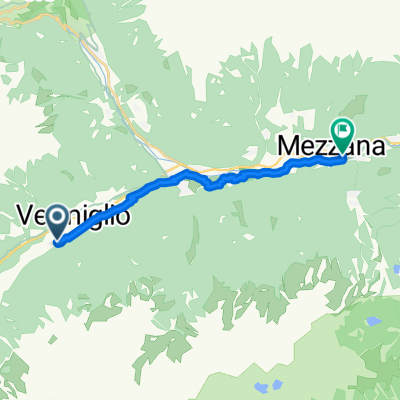
Tas - Vermiglio
A cycling route starting in Vermiglio, Trentino-Alto Adige, Italy.
Overview
About this route
Itinerario facile e poco faticoso, si snoda sul bel fondovalle del torrente Vermigliana, dai Laghetti di San Leonardo alla boscosa area picnic “Le Viscle”, con breve divagazione nella scenografica Val Stavel. Il nome deriva dall'habitat del tasso, inconfondibile mustelide dalle tipiche strisce longitudinali nere sul lungo muso bianco, che vive in tane sotterranee al limite del bosco ed esce prevalentemente di notte per girovagare nei prati alla ricerca di cibo.
- -:--
- Duration
- 12.1 km
- Distance
- 250 m
- Ascent
- 252 m
- Descent
- ---
- Avg. speed
- ---
- Max. altitude
Continue with Bikemap
Use, edit, or download this cycling route
You would like to ride Tas - Vermiglio or customize it for your own trip? Here is what you can do with this Bikemap route:
Free features
- Save this route as favorite or in collections
- Copy & plan your own version of this route
- Sync your route with Garmin or Wahoo
Premium features
Free trial for 3 days, or one-time payment. More about Bikemap Premium.
- Navigate this route on iOS & Android
- Export a GPX / KML file of this route
- Create your custom printout (try it for free)
- Download this route for offline navigation
Discover more Premium features.
Get Bikemap PremiumFrom our community
Other popular routes starting in Vermiglio
 Montozzo da Velon a Cogolo
- Distance
- 39.5 km
- Ascent
- 1,516 m
- Descent
- 1,668 m
- Location
- Vermiglio, Trentino-Alto Adige, Italy
 GIRO DEI FORTI AUSTRIACI (CEDRON)
- Distance
- 38.2 km
- Ascent
- 1,242 m
- Descent
- 1,242 m
- Location
- Vermiglio, Trentino-Alto Adige, Italy
 Mortirolo-Zoncolan
- Distance
- 104.5 km
- Ascent
- 3,515 m
- Descent
- 2,695 m
- Location
- Vermiglio, Trentino-Alto Adige, Italy
 fadsfasd
- Distance
- 56.1 km
- Ascent
- 668 m
- Descent
- 876 m
- Location
- Vermiglio, Trentino-Alto Adige, Italy
 Vanaf W van Bolzano naar Lugano
- Distance
- 383.1 km
- Ascent
- 6,147 m
- Descent
- 5,909 m
- Location
- Vermiglio, Trentino-Alto Adige, Italy
 6: Vermiglio - Sondrio
- Distance
- 81.9 km
- Ascent
- 1,240 m
- Descent
- 2,163 m
- Location
- Vermiglio, Trentino-Alto Adige, Italy
 ponte di legno to riva del garda part 2
- Distance
- 113 km
- Ascent
- 1,369 m
- Descent
- 2,729 m
- Location
- Vermiglio, Trentino-Alto Adige, Italy
 Vermiglio a Via IV Novembre, Mezzana
- Distance
- 12.2 km
- Ascent
- 69 m
- Descent
- 349 m
- Location
- Vermiglio, Trentino-Alto Adige, Italy
Open it in the app