

Windpark Pretul: Bärenkogel - Ganzalm - Roseggerhaus
A cycling route starting in Mürzzuschlag, Styria, Austria.
Overview
About this route
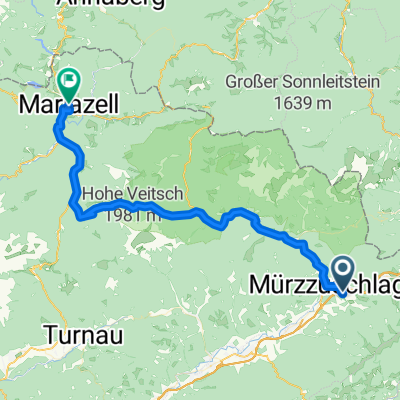
Wir starten in Mürzzuschlag am Stadtplatz und fahren den Radweg R5 entlang bis zum Gasthof Lendl. Direkt über den Parkplatz beim GH Lendl unter der Autobahnbrücke durch und dann die Auffahrt Bärenkogel nehmen.
Zuerst über die Asphaltstrasse bis zum Parkplatz am Bärenkogelsattel. Hier beginnt die offizielle MTB-Strecke auf die Ganzalm und die Pretul Windpark-Runden.
Wir fahren zuerst bis auf die Ganzalm, wo man sich beim Naturfreundehaus stärken kann bevor es weiter geht.
50 Meter nach dem Naturfreundehaus muss man sich entscheiden, ob man über den Ganzweg die Route Richtung Moschkogel wählt oder ob man geradeaus bergauf in Richtung Amundsenhöhe und Roseggerhaus fährt, wofür wir uns entscheiden.
Beim Roseggerhaus, das ganzjährig geöffnet ist, einkehren und entscheiden ob man die Windpark-Runde über die Pretul auf die Schwarzriegelalm oder Moschkogel weiterfährt oder ob man wieder über die gleiche Strecke retour bergab ins Tal fährt.
- -:--
- Duration
- 11.3 km
- Distance
- 898 m
- Ascent
- 12 m
- Descent
- ---
- Avg. speed
- ---
- Avg. speed
Route quality
Waytypes & surfaces along the route
Waytypes
Track
6.9 km
(62 %)
Quiet road
4.3 km
(38 %)
Undefined
0 km
(<1 %)
Surfaces
Paved
4.3 km
(38 %)
Unpaved
6.8 km
(60 %)
Gravel
6.8 km
(60 %)
Asphalt
4.3 km
(38 %)
Undefined
0.2 km
(2 %)
Continue with Bikemap
Use, edit, or download this cycling route
You would like to ride Windpark Pretul: Bärenkogel - Ganzalm - Roseggerhaus or customize it for your own trip? Here is what you can do with this Bikemap route:
Free features
- Save this route as favorite or in collections
- Copy & plan your own version of this route
- Sync your route with Garmin or Wahoo
Premium features
Free trial for 3 days, or one-time payment. More about Bikemap Premium.
- Navigate this route on iOS & Android
- Export a GPX / KML file of this route
- Create your custom printout (try it for free)
- Download this route for offline navigation
Discover more Premium features.
Get Bikemap PremiumFrom our community
Other popular routes starting in Mürzzuschlag
 20130518
- Distance
- 54.4 km
- Ascent
- 713 m
- Descent
- 579 m
- Location
- Mürzzuschlag, Styria, Austria
 L118 79b, Mürzzuschlag to L118 79b, Mürzzuschlag
- Distance
- 20.9 km
- Ascent
- 870 m
- Descent
- 874 m
- Location
- Mürzzuschlag, Styria, Austria
 Mürzzuschlag - Selzthal
- Distance
- 151.7 km
- Ascent
- 1,276 m
- Descent
- 1,305 m
- Location
- Mürzzuschlag, Styria, Austria
 Turnau
- Distance
- 100.2 km
- Ascent
- 1,427 m
- Descent
- 1,476 m
- Location
- Mürzzuschlag, Styria, Austria
 Mürzzuschlag - Bruck an der Mur
- Distance
- 45.4 km
- Ascent
- 76 m
- Descent
- 250 m
- Location
- Mürzzuschlag, Styria, Austria
 Savudrija Radtour
- Distance
- 429.6 km
- Ascent
- 2,359 m
- Descent
- 3,010 m
- Location
- Mürzzuschlag, Styria, Austria
 Preiner Gschaid - Semmering
- Distance
- 68.8 km
- Ascent
- 1,128 m
- Descent
- 1,123 m
- Location
- Mürzzuschlag, Styria, Austria
 GANSTAL RUNDE
- Distance
- 9.8 km
- Ascent
- 322 m
- Descent
- 345 m
- Location
- Mürzzuschlag, Styria, Austria
Open it in the app