

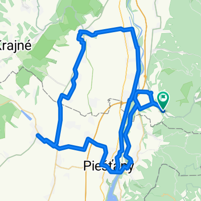
Piešťany - Tesáre - Topoľčany
A cycling route starting in Piešťany, Trnava Region, Slovakia.
Overview
About this route
Asfalt - cesty, polne / lesne cesty
- -:--
- Duration
- 47.9 km
- Distance
- 976 m
- Ascent
- 961 m
- Descent
- ---
- Avg. speed
- 623 m
- Max. altitude

Route quality
Waytypes & surfaces along the route
Waytypes
Track
30.1 km
(63 %)
Road
6.7 km
(14 %)
Surfaces
Paved
6.7 km
(14 %)
Unpaved
27.3 km
(57 %)
Loose gravel
11.5 km
(24 %)
Ground
7.7 km
(16 %)
Continue with Bikemap
Use, edit, or download this cycling route
You would like to ride Piešťany - Tesáre - Topoľčany or customize it for your own trip? Here is what you can do with this Bikemap route:
Free features
- Save this route as favorite or in collections
- Copy & plan your own version of this route
- Sync your route with Garmin or Wahoo
Premium features
Free trial for 3 days, or one-time payment. More about Bikemap Premium.
- Navigate this route on iOS & Android
- Export a GPX / KML file of this route
- Create your custom printout (try it for free)
- Download this route for offline navigation
Discover more Premium features.
Get Bikemap PremiumFrom our community
Other popular routes starting in Piešťany
 Modrová - Vrbové - Modrová
- Distance
- 79 km
- Ascent
- 223 m
- Descent
- 222 m
- Location
- Piešťany, Trnava Region, Slovakia
 Piešťany - Výtoky - Jelenie Jamy
- Distance
- 13.4 km
- Ascent
- 583 m
- Descent
- 166 m
- Location
- Piešťany, Trnava Region, Slovakia
 Piešťany - Vrbové - Lančár / Lančárska dolina
- Distance
- 22.9 km
- Ascent
- 256 m
- Descent
- 45 m
- Location
- Piešťany, Trnava Region, Slovakia
 Piešťany - Veľké Orvište - Podolie (Park miniatúr)
- Distance
- 15.3 km
- Ascent
- 17 m
- Descent
- 0 m
- Location
- Piešťany, Trnava Region, Slovakia
 Piešťany- Horná Streda- Nové Mesto n. Váhom
- Distance
- 21.5 km
- Ascent
- 37 m
- Descent
- 16 m
- Location
- Piešťany, Trnava Region, Slovakia
 Piešťany - Prievaly
- Distance
- 69.2 km
- Ascent
- 1,535 m
- Descent
- 1,449 m
- Location
- Piešťany, Trnava Region, Slovakia
 Piešťany - Madunice
- Distance
- 15.7 km
- Ascent
- 22 m
- Descent
- 37 m
- Location
- Piešťany, Trnava Region, Slovakia
 Piešťany - Trebatice - Čachtice
- Distance
- 23.2 km
- Ascent
- 171 m
- Descent
- 7 m
- Location
- Piešťany, Trnava Region, Slovakia
Open it in the app