
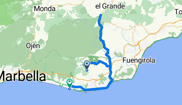
El soto de Marbella - Alhaurin - Elviria
A cycling route starting in Fuengirola, Andalusia, Spain.
Overview
About this route
- 2 h 16 min
- Duration
- 46.2 km
- Distance
- 1,390 m
- Ascent
- 1,681 m
- Descent
- 20.4 km/h
- Avg. speed
- ---
- Avg. speed

Continue with Bikemap
Use, edit, or download this cycling route
You would like to ride El soto de Marbella - Alhaurin - Elviria or customize it for your own trip? Here is what you can do with this Bikemap route:
Free features
- Save this route as favorite or in collections
- Copy & plan your own version of this route
- Sync your route with Garmin or Wahoo
Premium features
Free trial for 3 days, or one-time payment. More about Bikemap Premium.
- Navigate this route on iOS & Android
- Export a GPX / KML file of this route
- Create your custom printout (try it for free)
- Download this route for offline navigation
Discover more Premium features.
Get Bikemap PremiumFrom our community
Other popular routes starting in Fuengirola
 Återhämtning med lite distans
- Distance
- 103.1 km
- Ascent
- 1,400 m
- Descent
- 1,403 m
- Location
- Fuengirola, Andalusia, Spain
 Hjem-Monda-Hjem
- Distance
- 65.4 km
- Ascent
- 1,032 m
- Descent
- 1,017 m
- Location
- Fuengirola, Andalusia, Spain
 La Cala- Estacion de Cártama - Pizarra - la Cala
- Distance
- 93.4 km
- Ascent
- 970 m
- Descent
- 973 m
- Location
- Fuengirola, Andalusia, Spain
 FGRL -- Repetidor
- Distance
- 14.2 km
- Ascent
- 977 m
- Descent
- 84 m
- Location
- Fuengirola, Andalusia, Spain
 distans light
- Distance
- 110.4 km
- Ascent
- 1,562 m
- Descent
- 1,565 m
- Location
- Fuengirola, Andalusia, Spain
 Fuengirola-Ojén-Fuengirola
- Distance
- 68.5 km
- Ascent
- 1,606 m
- Descent
- 1,530 m
- Location
- Fuengirola, Andalusia, Spain
 dag 2 återhämtning
- Distance
- 85.9 km
- Ascent
- 1,001 m
- Descent
- 1,004 m
- Location
- Fuengirola, Andalusia, Spain
 Fuengirola - Sierra Prieta - Fuengirola
- Distance
- 123.2 km
- Ascent
- 1,578 m
- Descent
- 1,573 m
- Location
- Fuengirola, Andalusia, Spain
Open it in the app