
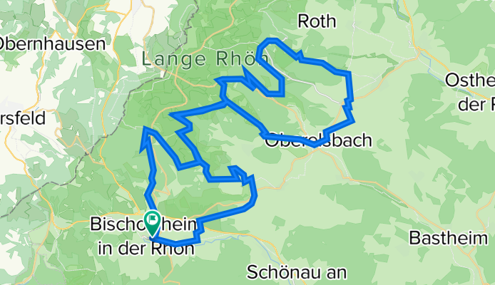
Mountainbike: Durch die Lange Rhön zum Haus der Langen Rhön
A cycling route starting in Bischofsheim an der Rhön, Bavaria, Germany.
Overview
About this route
Ausgangspunkt: Bischofsheim Zentralparkplatz
Streckenlänge: ca. 55 km
Höhendifferenzen: ca. 1200 hm
Höchste Punkte: Basaltsee (715m), Thüringer Hütte (700m), Mittelhut (832m; Infotafeln)
Schwierigkeiten: Mittelschwere Tour mit einigen starken Steigungen
Wege: Natur- und Schotterwege, wenig Asphalt
Markierung: Mountinbike-Routennetz
Karte: Mountinbike-Routenkarte Rhön
Einkehr: Basaltsee, Thüringer Hütte, Schweinfurter Haus
Interessantes am Weg: Basaltsee, Lehrpfad Gangolfsberg (zu Fuß ab Schweinfurter Haus), Haus der Langen Rhön
- -:--
- Duration
- 55.7 km
- Distance
- 1,275 m
- Ascent
- 1,284 m
- Descent
- ---
- Avg. speed
- 837 m
- Avg. speed
Route quality
Waytypes & surfaces along the route
Waytypes
Track
36.6 km
(66 %)
Quiet road
5.6 km
(10 %)
Surfaces
Paved
18.5 km
(33 %)
Unpaved
32.7 km
(59 %)
Loose gravel
20.6 km
(37 %)
Asphalt
17.3 km
(31 %)
Continue with Bikemap
Use, edit, or download this cycling route
You would like to ride Mountainbike: Durch die Lange Rhön zum Haus der Langen Rhön or customize it for your own trip? Here is what you can do with this Bikemap route:
Free features
- Save this route as favorite or in collections
- Copy & plan your own version of this route
- Sync your route with Garmin or Wahoo
Premium features
Free trial for 3 days, or one-time payment. More about Bikemap Premium.
- Navigate this route on iOS & Android
- Export a GPX / KML file of this route
- Create your custom printout (try it for free)
- Download this route for offline navigation
Discover more Premium features.
Get Bikemap PremiumFrom our community
Other popular routes starting in Bischofsheim an der Rhön
 Mountinbike: Die Vier-Gipfel-Tour
- Distance
- 57.3 km
- Ascent
- 1,355 m
- Descent
- 1,353 m
- Location
- Bischofsheim an der Rhön, Bavaria, Germany
 DURCH DIE LANGE RHÖN ZUM HAUS DER LANGEN RHÖN
- Distance
- 55.8 km
- Ascent
- 1,185 m
- Descent
- 1,184 m
- Location
- Bischofsheim an der Rhön, Bavaria, Germany
 Milseburgrunde
- Distance
- 103.5 km
- Ascent
- 1,348 m
- Descent
- 1,386 m
- Location
- Bischofsheim an der Rhön, Bavaria, Germany
 Possible_FlowTrail_to_Schoenau
- Distance
- 9.5 km
- Ascent
- 113 m
- Descent
- 400 m
- Location
- Bischofsheim an der Rhön, Bavaria, Germany
 Zwischen Wasserkuppe und Kreuzberg
- Distance
- 43.8 km
- Ascent
- 1,231 m
- Descent
- 1,231 m
- Location
- Bischofsheim an der Rhön, Bavaria, Germany
 Bischofsheim Kloster Kreuzberg
- Distance
- 5.9 km
- Ascent
- 496 m
- Descent
- 47 m
- Location
- Bischofsheim an der Rhön, Bavaria, Germany
 Rhönrunde
- Distance
- 84 km
- Ascent
- 1,289 m
- Descent
- 1,289 m
- Location
- Bischofsheim an der Rhön, Bavaria, Germany
 Heimfahrt von Bischofsheim/Rhön nach FO (über NES, Bad Kö.hofen, Ebern, Bbg.)
- Distance
- 131.2 km
- Ascent
- 331 m
- Descent
- 512 m
- Location
- Bischofsheim an der Rhön, Bavaria, Germany
Open it in the app