

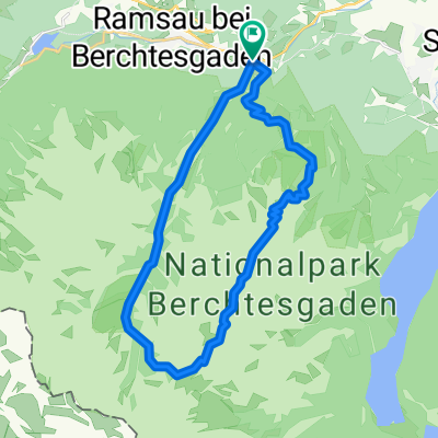
Bindalm vom Hintersee Berchtesgaden
A cycling route starting in Ramsau, Bavaria, Germany.
Overview
About this route
Ab Hintersee alles auf Teerstraße. Achtung es gibt Busverkehr auf der Strecke. Die letzten Meter sind sehr steil, aber sehr schöne Tour. Wer mag weiter auf der Teerstr. über die Grenze nach Österreich. ca. 80 m nach der Grenze rechts denm festen Schotterweg weiter zur Litzlalm. Beschilderung folgen. Schöne Almen, sind bewirtschaftet. Litzlalm mit Speisen und Getränken. Schönes Bergpanorama.
- -:--
- Duration
- 15.8 km
- Distance
- 486 m
- Ascent
- 485 m
- Descent
- ---
- Avg. speed
- ---
- Avg. speed
Route quality
Waytypes & surfaces along the route
Waytypes
Quiet road
13.8 km
(87 %)
Road
1.2 km
(7 %)
Surfaces
Paved
15 km
(95 %)
Unpaved
0.9 km
(5 %)
Asphalt
15 km
(95 %)
Unpaved (undefined)
0.7 km
(4 %)
Continue with Bikemap
Use, edit, or download this cycling route
You would like to ride Bindalm vom Hintersee Berchtesgaden or customize it for your own trip? Here is what you can do with this Bikemap route:
Free features
- Save this route as favorite or in collections
- Copy & plan your own version of this route
- Sync your route with Garmin or Wahoo
Premium features
Free trial for 3 days, or one-time payment. More about Bikemap Premium.
- Navigate this route on iOS & Android
- Export a GPX / KML file of this route
- Create your custom printout (try it for free)
- Download this route for offline navigation
Discover more Premium features.
Get Bikemap PremiumFrom our community
Other popular routes starting in Ramsau
 Berchtesgaden great loop
- Distance
- 46.7 km
- Ascent
- 1,548 m
- Descent
- 1,545 m
- Location
- Ramsau, Bavaria, Germany
 2022 Ramsau - Kehlstein
- Distance
- 22.2 km
- Ascent
- 1,499 m
- Descent
- 611 m
- Location
- Ramsau, Bavaria, Germany
 Kallbrunnalm_Jausenstation
- Distance
- 18.2 km
- Ascent
- 880 m
- Descent
- 300 m
- Location
- Ramsau, Bavaria, Germany
 Hirschbichl Testrunde
- Distance
- 57.1 km
- Ascent
- 891 m
- Descent
- 891 m
- Location
- Ramsau, Bavaria, Germany
 05_Wimbachtal
- Distance
- 17.1 km
- Ascent
- 695 m
- Descent
- 695 m
- Location
- Ramsau, Bavaria, Germany
 Hochschwarzeck-Bad Reichenhall-Hochschwarzeck
- Distance
- 39 km
- Ascent
- 818 m
- Descent
- 816 m
- Location
- Ramsau, Bavaria, Germany
 Watzmann Überschreitung
- Distance
- 22.3 km
- Ascent
- 2,035 m
- Descent
- 2,034 m
- Location
- Ramsau, Bavaria, Germany
 Rund um die Reiteralpe
- Distance
- 47.8 km
- Ascent
- 1,217 m
- Descent
- 1,217 m
- Location
- Ramsau, Bavaria, Germany
Open it in the app