

Cicloturismo Aspe - Hondones - Algueña - Romana- Aspe
A cycling route starting in Aspe, Valencia, Spain.
Overview
About this route
Planificada... para hacer ... nusca salir al maximos de carreteras
- -:--
- Duration
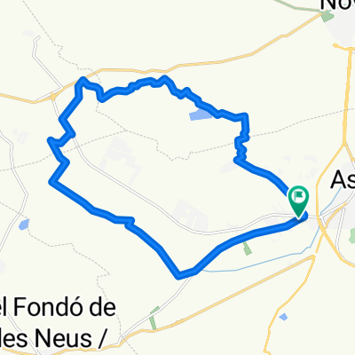
- 51.3 km
- Distance
- 417 m
- Ascent
- 421 m
- Descent
- ---
- Avg. speed
- ---
- Max. altitude
Route quality
Waytypes & surfaces along the route
Waytypes
Quiet road
19.5 km
(38 %)
Busy road
15.2 km
(30 %)
Surfaces
Paved
6 km
(12 %)
Asphalt
6 km
(12 %)
Undefined
45.3 km
(88 %)
Continue with Bikemap
Use, edit, or download this cycling route
You would like to ride Cicloturismo Aspe - Hondones - Algueña - Romana- Aspe or customize it for your own trip? Here is what you can do with this Bikemap route:
Free features
- Save this route as favorite or in collections
- Copy & plan your own version of this route
- Sync your route with Garmin or Wahoo
Premium features
Free trial for 3 days, or one-time payment. More about Bikemap Premium.
- Navigate this route on iOS & Android
- Export a GPX / KML file of this route
- Create your custom printout (try it for free)
- Download this route for offline navigation
Discover more Premium features.
Get Bikemap PremiumFrom our community
Other popular routes starting in Aspe
 Aspe 001
- Distance
- 19.3 km
- Ascent
- 154 m
- Descent
- 154 m
- Location
- Aspe, Valencia, Spain
 Vuelta rápida 1 horita.
- Distance
- 17 km
- Ascent
- 199 m
- Descent
- 239 m
- Location
- Aspe, Valencia, Spain
 aspe monovar
- Distance
- 14.4 km
- Ascent
- 261 m
- Descent
- 97 m
- Location
- Aspe, Valencia, Spain
 Cicloturismo Aspe - Hondones - Algueña - Romana- Aspe
- Distance
- 51.3 km
- Ascent
- 417 m
- Descent
- 421 m
- Location
- Aspe, Valencia, Spain
 Ruta 17 : Marcha Vall de las Uvas - Monforte del Cid
- Distance
- 65.2 km
- Ascent
- 510 m
- Descent
- 499 m
- Location
- Aspe, Valencia, Spain
 Propuesta de Ruta Font de la Gota - Barranc Arcs - Azafá
- Distance
- 11.8 km
- Ascent
- 344 m
- Descent
- 344 m
- Location
- Aspe, Valencia, Spain
 De Plaza del Polígono 50, 51, Aspe a Plaza del Polígono 50, 48, Aspe
- Distance
- 22.4 km
- Ascent
- 365 m
- Descent
- 366 m
- Location
- Aspe, Valencia, Spain
 20. Aspe - Alhama
- Distance
- 108.2 km
- Ascent
- 498 m
- Descent
- 500 m
- Location
- Aspe, Valencia, Spain
Open it in the app