
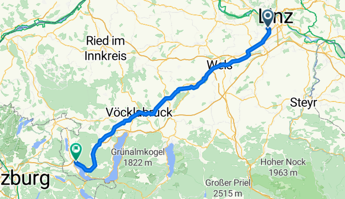
Leonding-Mondsee
A cycling route starting in Leonding, Upper Austria, Austria.
Overview
About this route
- -:--
- Duration
- 102.5 km
- Distance
- 478 m
- Ascent
- 257 m
- Descent
- ---
- Avg. speed
- ---
- Avg. speed

Route quality
Waytypes & surfaces along the route
Waytypes
Quiet road
32.7 km
(32 %)
Busy road
20.7 km
(20 %)
Surfaces
Paved
48.4 km
(47 %)
Unpaved
11.2 km
(11 %)
Asphalt
45.6 km
(44 %)
Gravel
8.5 km
(8 %)
Continue with Bikemap
Use, edit, or download this cycling route
You would like to ride Leonding-Mondsee or customize it for your own trip? Here is what you can do with this Bikemap route:
Free features
- Save this route as favorite or in collections
- Copy & plan your own version of this route
- Sync your route with Garmin or Wahoo
Premium features
Free trial for 3 days, or one-time payment. More about Bikemap Premium.
- Navigate this route on iOS & Android
- Export a GPX / KML file of this route
- Create your custom printout (try it for free)
- Download this route for offline navigation
Discover more Premium features.
Get Bikemap PremiumFrom our community
Other popular routes starting in Leonding
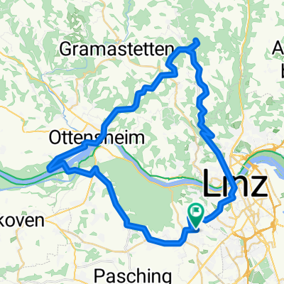 Leonding-Gis-Ottensheim-Leonding
- Distance
- 45.6 km
- Ascent
- 842 m
- Descent
- 835 m
- Location
- Leonding, Upper Austria, Austria
 Trail Kürnbergburg – Rufling
- Distance
- 1.8 km
- Ascent
- 25 m
- Descent
- 195 m
- Location
- Leonding, Upper Austria, Austria
 Trail Friesenegg – Freinberg
- Distance
- 1.7 km
- Ascent
- 15 m
- Descent
- 58 m
- Location
- Leonding, Upper Austria, Austria
 RR10_2015_06_10-Traunweg Nord-Marchtr.
- Distance
- 41.4 km
- Ascent
- 60 m
- Descent
- 58 m
- Location
- Leonding, Upper Austria, Austria
 Linz-Alhaming-Pichling
- Distance
- 64.1 km
- Ascent
- 418 m
- Descent
- 421 m
- Location
- Leonding, Upper Austria, Austria
 RR19-20150824_140332.gpx
- Distance
- 57.1 km
- Ascent
- 137 m
- Descent
- 137 m
- Location
- Leonding, Upper Austria, Austria
 Linz - Wallsee - Linz
- Distance
- 88.4 km
- Ascent
- 95 m
- Descent
- 95 m
- Location
- Leonding, Upper Austria, Austria
 Harald's Abendroute
- Distance
- 17.3 km
- Ascent
- 42 m
- Descent
- 43 m
- Location
- Leonding, Upper Austria, Austria
Open it in the app