

Köln_Linz am Rhein
A cycling route starting in Bayenthal, North Rhine-Westphalia, Germany.
Overview
About this route
Cologne_Linz am Rhein
Length: 60 km Start Chokoladenmuseum 9:30 AM- -:--
- Duration
- 58.1 km
- Distance
- 159 m
- Ascent
- 147 m
- Descent
- ---
- Avg. speed
- 76 m
- Max. altitude

Route quality
Waytypes & surfaces along the route
Waytypes
Path
31.4 km
(54 %)
Quiet road
9.3 km
(16 %)
Surfaces
Paved
46.5 km
(80 %)
Unpaved
0.6 km
(1 %)
Asphalt
46.5 km
(80 %)
Loose gravel
0.6 km
(1 %)
Undefined
11 km
(19 %)
Route highlights
Points of interest along the route

Photo after 0 km
Aggripinawerft

Photo after 3.3 km
Köln-Rodenkirchen

Photo after 6.4 km
Weißer Unterkölnweg

Photo after 9.6 km
Rheinufer, Sürth

Photo after 17.3 km
Leinpfad am Rhein

Photo after 25.8 km
Eschenallee am Rhein

Photo after 33.6 km
Bonn, Villa Hammerschmidt

Photo after 38.2 km
BONN : Gebäude der UNO

Photo after 44.6 km
Rolandswerth mit Blick auf den Drachenfels

Photo after 47.2 km
Oberwinter - Regenfänger

Photo after 51.1 km
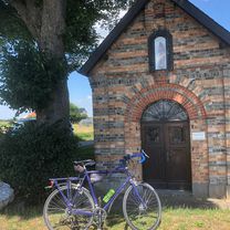
Wallfahrtskirche Sankt Apollinaris

Photo after 53.5 km
Brücke von Remagen

Point of interest after 56.6 km
Fähre zwischen Remagen und Linz

Photo after 57.3 km
Markzplatz Linz am Rhein

Point of interest after 58.1 km
Bahnhof Linz(Rhein)
Continue with Bikemap
Use, edit, or download this cycling route
You would like to ride Köln_Linz am Rhein or customize it for your own trip? Here is what you can do with this Bikemap route:
Free features
- Save this route as favorite or in collections
- Copy & plan your own version of this route
- Sync your route with Garmin or Wahoo
Premium features
Free trial for 3 days, or one-time payment. More about Bikemap Premium.
- Navigate this route on iOS & Android
- Export a GPX / KML file of this route
- Create your custom printout (try it for free)
- Download this route for offline navigation
Discover more Premium features.
Get Bikemap PremiumFrom our community
Other popular routes starting in Bayenthal
 Köln-Ruhrtal und zurück 150 Km
- Distance
- 153.2 km
- Ascent
- 737 m
- Descent
- 724 m
- Location
- Bayenthal, North Rhine-Westphalia, Germany
 Um die Dhünntalsperre
- Distance
- 91.9 km
- Ascent
- 884 m
- Descent
- 876 m
- Location
- Bayenthal, North Rhine-Westphalia, Germany
 Köln_Linz am Rhein
- Distance
- 58.1 km
- Ascent
- 159 m
- Descent
- 147 m
- Location
- Bayenthal, North Rhine-Westphalia, Germany
 Südstadt-Bliesheim-Kippe-heim
- Distance
- 71 km
- Ascent
- 261 m
- Descent
- 263 m
- Location
- Bayenthal, North Rhine-Westphalia, Germany
 Route in Köln
- Distance
- 39.3 km
- Ascent
- 181 m
- Descent
- 180 m
- Location
- Bayenthal, North Rhine-Westphalia, Germany
 Neukirchener Tour
- Distance
- 70.5 km
- Ascent
- 239 m
- Descent
- 239 m
- Location
- Bayenthal, North Rhine-Westphalia, Germany
 Köln_Süd - Bonn
- Distance
- 31.9 km
- Ascent
- 23 m
- Descent
- 20 m
- Location
- Bayenthal, North Rhine-Westphalia, Germany
 CCC-K #3 Bensberg Spitze
- Distance
- 62.6 km
- Ascent
- 550 m
- Descent
- 553 m
- Location
- Bayenthal, North Rhine-Westphalia, Germany
Open it in the app