

Podhorská etapa Jaunstein k lanovce Unterort.
A cycling route starting in Gallizien, Carinthia, Austria.
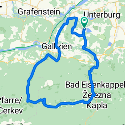
Overview
About this route
Kopcovitější v podhůří, lze i lanovkou do 1700 m, nebo v Jaunsteinu zkrátit asi na 35 a opět se vykoupat v Turnersee.
- -:--
- Duration
- 51 km
- Distance
- 294 m
- Ascent
- 308 m
- Descent
- ---
- Avg. speed
- ---
- Avg. speed

Route quality
Waytypes & surfaces along the route
Waytypes
Road
17.2 km
(34 %)
Quiet road
15.3 km
(30 %)
Surfaces
Paved
9.5 km
(19 %)
Unpaved
4.7 km
(9 %)
Asphalt
8.8 km
(17 %)
Gravel
3.7 km
(7 %)
Continue with Bikemap
Use, edit, or download this cycling route
You would like to ride Podhorská etapa Jaunstein k lanovce Unterort. or customize it for your own trip? Here is what you can do with this Bikemap route:
Free features
- Save this route as favorite or in collections
- Copy & plan your own version of this route
- Sync your route with Garmin or Wahoo
Premium features
Free trial for 3 days, or one-time payment. More about Bikemap Premium.
- Navigate this route on iOS & Android
- Export a GPX / KML file of this route
- Create your custom printout (try it for free)
- Download this route for offline navigation
Discover more Premium features.
Get Bikemap PremiumFrom our community
Other popular routes starting in Gallizien
 Klopeinské jezero - Klagenfurt a z5
- Distance
- 70.3 km
- Ascent
- 897 m
- Descent
- 897 m
- Location
- Gallizien, Carinthia, Austria
 Unternarrach 50 naar Turnersee Campingplatz
- Distance
- 56.9 km
- Ascent
- 1,179 m
- Descent
- 1,197 m
- Location
- Gallizien, Carinthia, Austria
 Donnerstag 08.07 29KM 160Hm Annabrücke
- Distance
- 28.7 km
- Ascent
- 128 m
- Descent
- 141 m
- Location
- Gallizien, Carinthia, Austria
 Hochobir-Strecke
- Distance
- 30.6 km
- Ascent
- 1,535 m
- Descent
- 871 m
- Location
- Gallizien, Carinthia, Austria
 Seidendorf - Wörthersee - Drauweg - Seidendorf - Seidendorf - Wörthersee - Drauweg - Seidendorf
- Distance
- 75.7 km
- Ascent
- 606 m
- Descent
- 606 m
- Location
- Gallizien, Carinthia, Austria
 Po řece Velach
- Distance
- 33.3 km
- Ascent
- 642 m
- Descent
- 627 m
- Location
- Gallizien, Carinthia, Austria
 Koschutarunde
- Distance
- 49.3 km
- Ascent
- 640 m
- Descent
- 640 m
- Location
- Gallizien, Carinthia, Austria
 Annabrücke Eberndorf Klopeinersee
- Distance
- 36.3 km
- Ascent
- 288 m
- Descent
- 289 m
- Location
- Gallizien, Carinthia, Austria
Open it in the app