

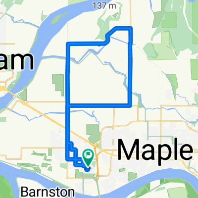
Pitt Meadows- Westwood Plateau- Buntzen- Belcarra-
A cycling route starting in Pitt Meadows, British Columbia, Canada.
Overview
About this route
Beautfiul scenery with an ascent to, and a partial lap of, Westwood Plateau Gold Course followed by a ride to Buntzen Lake with a steep descent leaving Anmore before starting a long climb to Belcarra before being rewarded with Pacific Ocean views before doing a long loop back to Pitt Meadows
- -:--
- Duration
- 67.8 km
- Distance
- 760 m
- Ascent
- 757 m
- Descent
- ---
- Avg. speed
- ---
- Avg. speed

Route quality
Waytypes & surfaces along the route
Waytypes
Quiet road
18.7 km
(28 %)
Road
15.8 km
(23 %)
Surfaces
Paved
46.8 km
(69 %)
Unpaved
4.9 km
(7 %)
Asphalt
45.1 km
(66 %)
Gravel
4.4 km
(7 %)
Continue with Bikemap
Use, edit, or download this cycling route
You would like to ride Pitt Meadows- Westwood Plateau- Buntzen- Belcarra- or customize it for your own trip? Here is what you can do with this Bikemap route:
Free features
- Save this route as favorite or in collections
- Copy & plan your own version of this route
- Sync your route with Garmin or Wahoo
Premium features
Free trial for 3 days, or one-time payment. More about Bikemap Premium.
- Navigate this route on iOS & Android
- Export a GPX / KML file of this route
- Create your custom printout (try it for free)
- Download this route for offline navigation
Discover more Premium features.
Get Bikemap PremiumFrom our community
Other popular routes starting in Pitt Meadows
 Lower Loop- Pitt Meadows
- Distance
- 29.3 km
- Ascent
- 72 m
- Descent
- 72 m
- Location
- Pitt Meadows, British Columbia, Canada
 Trail Pavilion to Shoreline Park and back
- Distance
- 28.7 km
- Ascent
- 89 m
- Descent
- 89 m
- Location
- Pitt Meadows, British Columbia, Canada
 11731 Baynes Rd, Pitt Meadows to 18863 Ford Rd, Pitt Meadows
- Distance
- 27.7 km
- Ascent
- 16 m
- Descent
- 13 m
- Location
- Pitt Meadows, British Columbia, Canada
 Meadows "P"
- Distance
- 23.4 km
- Ascent
- 85 m
- Descent
- 88 m
- Location
- Pitt Meadows, British Columbia, Canada
 Home to Tynehead Trail then return
- Distance
- 12.4 km
- Ascent
- 124 m
- Descent
- 124 m
- Location
- Pitt Meadows, British Columbia, Canada
 Easy ride in Pitt Meadows
- Distance
- 6.9 km
- Ascent
- 0 m
- Descent
- 0 m
- Location
- Pitt Meadows, British Columbia, Canada
 Emmett’s house
- Distance
- 8.9 km
- Ascent
- 13 m
- Descent
- 26 m
- Location
- Pitt Meadows, British Columbia, Canada
 5337–11529 Kennedy Rd, Pitt Meadows to 863 Village Dr, Port Coquitlam
- Distance
- 31.7 km
- Ascent
- 6 m
- Descent
- 10 m
- Location
- Pitt Meadows, British Columbia, Canada
Open it in the app