

Schwarza-Domäne Groschwitz
A cycling route starting in Rudolstadt, Free State of Thuringia, Germany.
Overview
About this route
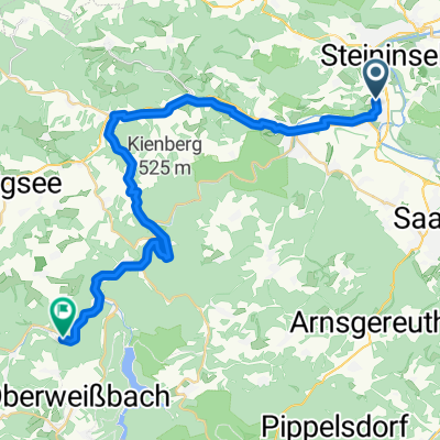
Landschaftlich herrliche Runde mit vielen Weitsichten ins schöne Thüringer Land um Rudolstadt
- -:--
- Duration
- 30.7 km
- Distance
- 427 m
- Ascent
- 428 m
- Descent
- ---
- Avg. speed
- ---
- Avg. speed

Continue with Bikemap
Use, edit, or download this cycling route
You would like to ride Schwarza-Domäne Groschwitz or customize it for your own trip? Here is what you can do with this Bikemap route:
Free features
- Save this route as favorite or in collections
- Copy & plan your own version of this route
- Sync your route with Garmin or Wahoo
Premium features
Free trial for 3 days, or one-time payment. More about Bikemap Premium.
- Navigate this route on iOS & Android
- Export a GPX / KML file of this route
- Create your custom printout (try it for free)
- Download this route for offline navigation
Discover more Premium features.
Get Bikemap PremiumFrom our community
Other popular routes starting in Rudolstadt
 Nach Remda und über die Herrenstraße zurück
- Distance
- 18.9 km
- Ascent
- 348 m
- Descent
- 348 m
- Location
- Rudolstadt, Free State of Thuringia, Germany
 MTB Tour 3
- Distance
- 25.5 km
- Ascent
- 439 m
- Descent
- 439 m
- Location
- Rudolstadt, Free State of Thuringia, Germany
 Ab durch den Wald.
- Distance
- 27.5 km
- Ascent
- 403 m
- Descent
- 405 m
- Location
- Rudolstadt, Free State of Thuringia, Germany
 RU-Oberweissbach-Solsdorf II
- Distance
- 82.5 km
- Ascent
- 1,219 m
- Descent
- 1,219 m
- Location
- Rudolstadt, Free State of Thuringia, Germany
 Rund um den Ehrenstein
- Distance
- 36.7 km
- Ascent
- 388 m
- Descent
- 388 m
- Location
- Rudolstadt, Free State of Thuringia, Germany
 Uphill von Teichröda zum Grünen Stern
- Distance
- 21.3 km
- Ascent
- 478 m
- Descent
- 456 m
- Location
- Rudolstadt, Free State of Thuringia, Germany
 Fahrradtour RU-Rottenbach-Bergbahn
- Distance
- 29.3 km
- Ascent
- 380 m
- Descent
- 263 m
- Location
- Rudolstadt, Free State of Thuringia, Germany
 Aufnahme vom 7. Juni 14:43
- Distance
- 51 km
- Ascent
- 554 m
- Descent
- 555 m
- Location
- Rudolstadt, Free State of Thuringia, Germany
Open it in the app