

Kopřivnický drtič 2018
A cycling route starting in Kopřivnice, Moravskoslezský kraj, Czechia.
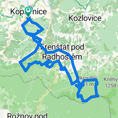
Overview
About this route
- -:--
- Duration
- 132.9 km
- Distance
- 2,209 m
- Ascent
- 2,210 m
- Descent
- ---
- Avg. speed
- ---
- Avg. speed
Route photos

Route highlights
Points of interest along the route
Point of interest after 23 km
K1
Point of interest after 34.2 km
K2
Point of interest after 49.4 km
K3
Point of interest after 53.9 km
K4
Point of interest after 73.7 km
K5
Point of interest after 87.8 km
K6
Point of interest after 95.6 km
K7
Point of interest after 113.3 km
K8
Continue with Bikemap
Use, edit, or download this cycling route
You would like to ride Kopřivnický drtič 2018 or customize it for your own trip? Here is what you can do with this Bikemap route:
Free features
- Save this route as favorite or in collections
- Copy & plan your own version of this route
- Sync your route with Garmin or Wahoo
Premium features
Free trial for 3 days, or one-time payment. More about Bikemap Premium.
- Navigate this route on iOS & Android
- Export a GPX / KML file of this route
- Create your custom printout (try it for free)
- Download this route for offline navigation
Discover more Premium features.
Get Bikemap PremiumFrom our community
Other popular routes starting in Kopřivnice
 Kopřivnický Drtič 2013
- Distance
- 116.8 km
- Ascent
- 2,395 m
- Descent
- 2,395 m
- Location
- Kopřivnice, Moravskoslezský kraj, Czechia
 roznov pres javornik dale pres Dily, Tanecnici, Solan, Benesky na Horni becvu.pak pres Mezivodi na Podolanky, Martinak, Pustevny a pres Frenstat a Lichnov do Ko
- Distance
- 104.9 km
- Ascent
- 1,830 m
- Descent
- 1,832 m
- Location
- Kopřivnice, Moravskoslezský kraj, Czechia
 koprivnice-pustevny-verovice-koprivnice
- Distance
- 58.9 km
- Ascent
- 1,237 m
- Descent
- 1,236 m
- Location
- Kopřivnice, Moravskoslezský kraj, Czechia
 Kolečko2-22.5.
- Distance
- 32.8 km
- Ascent
- 315 m
- Descent
- 315 m
- Location
- Kopřivnice, Moravskoslezský kraj, Czechia
 Radhošť + Kozlovice-2.8.2011
- Distance
- 70.7 km
- Ascent
- 963 m
- Descent
- 963 m
- Location
- Kopřivnice, Moravskoslezský kraj, Czechia
 pres Lysou na Visalaje po trase Drtice. Potom na Ostravici, Čeladnou a Pustevny. Přes Fren směr Lichnov a po kopřivnicke strane kopce na janikovku a dolu do Kop
- Distance
- 107.2 km
- Ascent
- 3,750 m
- Descent
- 3,421 m
- Location
- Kopřivnice, Moravskoslezský kraj, Czechia
 Poodří 1-30.7.11
- Distance
- 49 km
- Ascent
- 208 m
- Descent
- 209 m
- Location
- Kopřivnice, Moravskoslezský kraj, Czechia
 Kolečko-14.5.
- Distance
- 52.9 km
- Ascent
- 443 m
- Descent
- 443 m
- Location
- Kopřivnice, Moravskoslezský kraj, Czechia
Open it in the app