
Brimham Rocks (Knaresborough) 2018-07-18
A cycling route starting in York, England, United Kingdom.
Overview
About this route
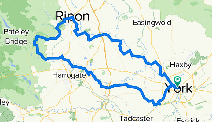
18/7/18 Joint ride, Knaresborough / Brimham Rocks – Leaders: Phil M; Andrew M. Elevenses Knaresborough Cafes (Black Mulberry, 01423 797930; Riverside Cafe, 01423 546759). Lunch Brimham Rocks (you are advised to bring sandwiches, though there is what can only be described as a shack where you can get tea and snacks). Route: Clifton Bridge, Acomb, Askam Bryan, Askam Richard, Long Marston, Knaresborough, Ripley,Clint, Birstwith, Ross Bridge (short stretch of unmetalled track here to avoid nasty hill and shorten route), Hartwith, Brimham Rocks, then follow Way of the Roses Signs back to York (Fountains Abbey, Ripon, Boroughbridge, Beningborough, York). A third stop will be taken somewhere on this route. 77 miles.
- -:--
- Duration
- 125.8 km
- Distance
- 364 m
- Ascent
- 364 m
- Descent
- ---
- Avg. speed
- ---
- Avg. speed

Continue with Bikemap
Use, edit, or download this cycling route
You would like to ride Brimham Rocks (Knaresborough) 2018-07-18 or customize it for your own trip? Here is what you can do with this Bikemap route:
Free features
- Save this route as favorite or in collections
- Copy & plan your own version of this route
- Sync your route with Garmin or Wahoo
Premium features
Free trial for 3 days, or one-time payment. More about Bikemap Premium.
- Navigate this route on iOS & Android
- Export a GPX / KML file of this route
- Create your custom printout (try it for free)
- Download this route for offline navigation
Discover more Premium features.
Get Bikemap PremiumFrom our community
Other popular routes starting in York
 Barton le willows
- Distance
- 49 km
- Ascent
- 141 m
- Descent
- 163 m
- Location
- York, England, United Kingdom
 York - Westow - York
- Distance
- 64.9 km
- Ascent
- 118 m
- Descent
- 114 m
- Location
- York, England, United Kingdom
 Ampleforth (Malton) 2018-05-30
- Distance
- 114.9 km
- Ascent
- 353 m
- Descent
- 360 m
- Location
- York, England, United Kingdom
 York - Crayke - York via Easingwold
- Distance
- 63.9 km
- Ascent
- 117 m
- Descent
- 115 m
- Location
- York, England, United Kingdom
 Fridaythorpe (Pockington) 2018-12-19
- Distance
- 84 km
- Ascent
- 395 m
- Descent
- 391 m
- Location
- York, England, United Kingdom
 Tockwith
- Distance
- 54.4 km
- Ascent
- 1,529 m
- Descent
- 1,525 m
- Location
- York, England, United Kingdom
 Tockwith Spotted Ox
- Distance
- 54.1 km
- Ascent
- 115 m
- Descent
- 110 m
- Location
- York, England, United Kingdom
 37 Monkgate, York to 33 Huntington Road, York
- Distance
- 16.1 km
- Ascent
- 6 m
- Descent
- 13 m
- Location
- York, England, United Kingdom
Open it in the app