

TCACTarget Field and River Loop
A cycling route starting in Minneapolis, Minnesota, United States of America.
Overview
About this route
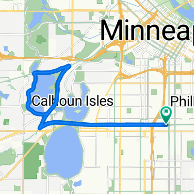
Nice mostly-flat ride for the adaptive cycling progra, 13.7 miles (22 km), starting at the Urban Ventures parking lot, following the Greenway west to the Kenilworth train exit, following the Kenilworth Trail until it merges with the Cedar Lake Trail, following the Cedar Lake Trail to the Mississippi, then following the Mississippi River Parkway Trail to the intersection with the Greenway. then returning to the starting point on the Greenway.
- -:--
- Duration
- 22.1 km
- Distance
- 97 m
- Ascent
- 97 m
- Descent
- ---
- Avg. speed
- ---
- Avg. speed

Continue with Bikemap
Use, edit, or download this cycling route
You would like to ride TCACTarget Field and River Loop or customize it for your own trip? Here is what you can do with this Bikemap route:
Free features
- Save this route as favorite or in collections
- Copy & plan your own version of this route
- Sync your route with Garmin or Wahoo
Premium features
Free trial for 3 days, or one-time payment. More about Bikemap Premium.
- Navigate this route on iOS & Android
- Export a GPX / KML file of this route
- Create your custom printout (try it for free)
- Download this route for offline navigation
Discover more Premium features.
Get Bikemap PremiumFrom our community
Other popular routes starting in Minneapolis
 TCAC Cedar Lake Loop
- Distance
- 15.9 km
- Ascent
- 55 m
- Descent
- 54 m
- Location
- Minneapolis, Minnesota, United States of America
 1512 Spruce Pl, Minneapolis to 1512 Spruce Pl, Minneapolis
- Distance
- 27.3 km
- Ascent
- 123 m
- Descent
- 123 m
- Location
- Minneapolis, Minnesota, United States of America
 Easy ride in Minneapolis
- Distance
- 13.1 km
- Ascent
- 448 m
- Descent
- 415 m
- Location
- Minneapolis, Minnesota, United States of America
 30 Miles
- Distance
- 46.5 km
- Ascent
- 122 m
- Descent
- 142 m
- Location
- Minneapolis, Minnesota, United States of America
 Tour de Luce
- Distance
- 100 km
- Ascent
- 620 m
- Descent
- 619 m
- Location
- Minneapolis, Minnesota, United States of America
 S Sixth St, Minneapolis to Spruce Pl, Minneapolis
- Distance
- 1.7 km
- Ascent
- 6 m
- Descent
- 21 m
- Location
- Minneapolis, Minnesota, United States of America
 East/West River Ride
- Distance
- 22.6 km
- Ascent
- 216 m
- Descent
- 217 m
- Location
- Minneapolis, Minnesota, United States of America
 Out to Minnetonka and back
- Distance
- 52 km
- Ascent
- 265 m
- Descent
- 264 m
- Location
- Minneapolis, Minnesota, United States of America
Open it in the app