

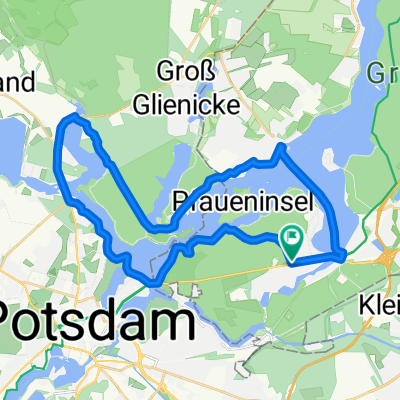
S Wannsee - Sacrow - S Heerstr
A cycling route starting in Wannsee, Land Berlin, Germany.
Overview
About this route
Interessante, landschaftliche schöne Strecke auf Radwegen oder sehr ruhigen Straßen. Ein schnuffiger Hügel (nicht steil) zu Beginn vor der Pfaueninsel. Ein paar kurze Pflaster-Stücke gibt es auch.
- -:--
- Duration
- 40.4 km
- Distance
- 196 m
- Ascent
- 182 m
- Descent
- ---
- Avg. speed
- ---
- Avg. speed

Route quality
Waytypes & surfaces along the route
Waytypes
Quiet road
14.3 km
(35 %)
Path
9.3 km
(23 %)
Surfaces
Paved
32 km
(79 %)
Unpaved
4.8 km
(12 %)
Asphalt
27.6 km
(68 %)
Loose gravel
2.5 km
(6 %)
Route highlights
Points of interest along the route
Photo after 5.1 km
Blick auf die Pfaueninsel
Photo after 8.6 km
Glienicker Brücke
Accommodation after 10.8 km
Biergarten
Photo after 20.6 km
Heilandskirche
Point of interest after 26.1 km
Fähre nach Wannsee, fährt immer um *:30.
Continue with Bikemap
Use, edit, or download this cycling route
You would like to ride S Wannsee - Sacrow - S Heerstr or customize it for your own trip? Here is what you can do with this Bikemap route:
Free features
- Save this route as favorite or in collections
- Copy & plan your own version of this route
- Sync your route with Garmin or Wahoo
Premium features
Free trial for 3 days, or one-time payment. More about Bikemap Premium.
- Navigate this route on iOS & Android
- Export a GPX / KML file of this route
- Create your custom printout (try it for free)
- Download this route for offline navigation
Discover more Premium features.
Get Bikemap PremiumFrom our community
Other popular routes starting in Wannsee
 Wannsee - Jungfernsee - Griebnitzsee - Gasthausbrauerei Meierei
- Distance
- 25.8 km
- Ascent
- 60 m
- Descent
- 55 m
- Location
- Wannsee, Land Berlin, Germany
 perm Havelseen
- Distance
- 65.6 km
- Ascent
- 276 m
- Descent
- 283 m
- Location
- Wannsee, Land Berlin, Germany
 Berliner Mauerweg Teil 2: Vom Wannsee bis zum Hauptbahnhof
- Distance
- 80.2 km
- Ascent
- 130 m
- Descent
- 144 m
- Location
- Wannsee, Land Berlin, Germany
 Wansee-Sacrow-Wansee
- Distance
- 29.4 km
- Ascent
- 210 m
- Descent
- 209 m
- Location
- Wannsee, Land Berlin, Germany
 8,5 km Wannsee Runde
- Distance
- 8.5 km
- Ascent
- 108 m
- Descent
- 88 m
- Location
- Wannsee, Land Berlin, Germany
 Vom Wannsee bis Fontanes Birnbaum
- Distance
- 73.1 km
- Ascent
- 112 m
- Descent
- 126 m
- Location
- Wannsee, Land Berlin, Germany
 Wannsee-Runde
- Distance
- 17.3 km
- Ascent
- 126 m
- Descent
- 128 m
- Location
- Wannsee, Land Berlin, Germany
 gemütliche
- Distance
- 11.3 km
- Ascent
- 163 m
- Descent
- 163 m
- Location
- Wannsee, Land Berlin, Germany
Open it in the app