

David's Attempt at the Triple Crown
A cycling route starting in Burnaby, British Columbia, Canada.
Overview
About this route
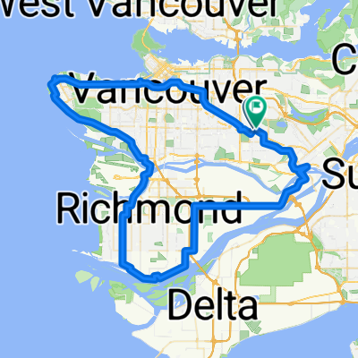
Park at Seymour but cycle towards Cypress along Marine Drive and climb up Cypress Mountain first, Grouse Mountain second, stay high and come down Mountain Hwy and tackle Seymour Mountain last; come down the mountain to your parked vehicle
- -:--
- Duration
- 99.5 km
- Distance
- 2,194 m
- Ascent
- 2,194 m
- Descent
- ---
- Avg. speed
- ---
- Avg. speed

Route quality
Waytypes & surfaces along the route
Waytypes
Road
48.8 km
(49 %)
Busy road
24.8 km
(25 %)
Surfaces
Paved
70.9 km
(71 %)
Unpaved
0.1 km
(<1 %)
Asphalt
54.5 km
(55 %)
Paved (undefined)
15.1 km
(15 %)
Continue with Bikemap
Use, edit, or download this cycling route
You would like to ride David's Attempt at the Triple Crown or customize it for your own trip? Here is what you can do with this Bikemap route:
Free features
- Save this route as favorite or in collections
- Copy & plan your own version of this route
- Sync your route with Garmin or Wahoo
Premium features
Free trial for 3 days, or one-time payment. More about Bikemap Premium.
- Navigate this route on iOS & Android
- Export a GPX / KML file of this route
- Create your custom printout (try it for free)
- Download this route for offline navigation
Discover more Premium features.
Get Bikemap PremiumFrom our community
Other popular routes starting in Burnaby
 East Van Breweries
- Distance
- 23.7 km
- Ascent
- 107 m
- Descent
- 107 m
- Location
- Burnaby, British Columbia, Canada
 4730 Lougheed Hwy, Burnaby to 21298 36 Ave, Langley
- Distance
- 41.2 km
- Ascent
- 357 m
- Descent
- 340 m
- Location
- Burnaby, British Columbia, Canada
 Donovan Ave, Burnaby to Donovan Ave, Burnaby
- Distance
- 21.5 km
- Ascent
- 178 m
- Descent
- 179 m
- Location
- Burnaby, British Columbia, Canada
 BBY Mtn to Stanley Park Loop
- Distance
- 62.5 km
- Ascent
- 934 m
- Descent
- 934 m
- Location
- Burnaby, British Columbia, Canada
 Route in Burnaby
- Distance
- 31.5 km
- Ascent
- 438 m
- Descent
- 436 m
- Location
- Burnaby, British Columbia, Canada
 North Burnaby to New Westminster Quay1...
- Distance
- 45.6 km
- Ascent
- 333 m
- Descent
- 338 m
- Location
- Burnaby, British Columbia, Canada
 Relaxed Wednesday Ride In Burnaby
- Distance
- 14 km
- Ascent
- 52 m
- Descent
- 146 m
- Location
- Burnaby, British Columbia, Canada
 burnaby ubc Richmond loop
- Distance
- 82.9 km
- Ascent
- 607 m
- Descent
- 607 m
- Location
- Burnaby, British Columbia, Canada
Open it in the app