

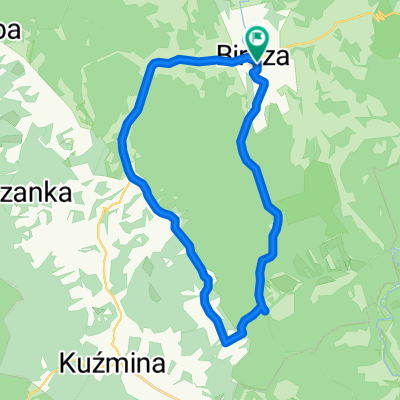
Roztoka
A cycling route starting in Bircza, Subcarpathian Voivodeship, Poland.
Overview
About this route
- -:--
- Duration
- 78.9 km
- Distance
- 865 m
- Ascent
- 865 m
- Descent
- ---
- Avg. speed
- ---
- Avg. speed
Route quality
Waytypes & surfaces along the route
Waytypes
Undefined
78.9 km
(100 %)
Surfaces
Undefined
78.9 km
(100 %)
Continue with Bikemap
Use, edit, or download this cycling route
You would like to ride Roztoka or customize it for your own trip? Here is what you can do with this Bikemap route:
Free features
- Save this route as favorite or in collections
- Copy & plan your own version of this route
- Sync your route with Garmin or Wahoo
Premium features
Free trial for 3 days, or one-time payment. More about Bikemap Premium.
- Navigate this route on iOS & Android
- Export a GPX / KML file of this route
- Create your custom printout (try it for free)
- Download this route for offline navigation
Discover more Premium features.
Get Bikemap PremiumFrom our community
Other popular routes starting in Bircza
 Posada Rybotycka-Trójca-Arłamów-Posada Rybotycka
- Distance
- 34.1 km
- Ascent
- 319 m
- Descent
- 314 m
- Location
- Bircza, Subcarpathian Voivodeship, Poland
 graziowa
- Distance
- 104.2 km
- Ascent
- 1,092 m
- Descent
- 1,092 m
- Location
- Bircza, Subcarpathian Voivodeship, Poland
 Bircza - južny okruh
- Distance
- 21.7 km
- Ascent
- 298 m
- Descent
- 298 m
- Location
- Bircza, Subcarpathian Voivodeship, Poland
 Bircza - juhovýchodný okruh - Artamow
- Distance
- 55.7 km
- Ascent
- 671 m
- Descent
- 673 m
- Location
- Bircza, Subcarpathian Voivodeship, Poland
 Dookoła Polski 2 dzień(Nowa Wieś-Strzebowiska)
- Distance
- 120 km
- Ascent
- 1,246 m
- Descent
- 824 m
- Location
- Bircza, Subcarpathian Voivodeship, Poland
 Leszczawa - Rezerwat Chwaniów - Arłamów
- Distance
- 72.4 km
- Ascent
- 959 m
- Descent
- 961 m
- Location
- Bircza, Subcarpathian Voivodeship, Poland
 2024_02_BikeMap
- Distance
- 134.6 km
- Ascent
- 953 m
- Descent
- 1,080 m
- Location
- Bircza, Subcarpathian Voivodeship, Poland
 plan na petle po pogorzu przemyskim
- Distance
- 84.6 km
- Ascent
- 1,006 m
- Descent
- 1,007 m
- Location
- Bircza, Subcarpathian Voivodeship, Poland