

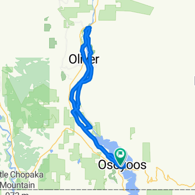
Channel - Black Sage Road
A cycling route starting in Osoyoos, British Columbia, Canada.
Overview
About this route
- -:--
- Duration
- 46.7 km
- Distance
- 175 m
- Ascent
- 175 m
- Descent
- ---
- Avg. speed
- ---
- Avg. speed

Route quality
Waytypes & surfaces along the route
Waytypes
Road
23.2 km
(50 %)
Cycleway
17.2 km
(37 %)
Surfaces
Paved
9.5 km
(20 %)
Unpaved
5.8 km
(12 %)
Paved (undefined)
6.3 km
(13 %)
Gravel
5.8 km
(12 %)
Continue with Bikemap
Use, edit, or download this cycling route
You would like to ride Channel - Black Sage Road or customize it for your own trip? Here is what you can do with this Bikemap route:
Free features
- Save this route as favorite or in collections
- Copy & plan your own version of this route
- Sync your route with Garmin or Wahoo
Premium features
Free trial for 3 days, or one-time payment. More about Bikemap Premium.
- Navigate this route on iOS & Android
- Export a GPX / KML file of this route
- Create your custom printout (try it for free)
- Download this route for offline navigation
Discover more Premium features.
Get Bikemap PremiumFrom our community
Other popular routes starting in Osoyoos
 Richters Pass and the Rollers v2
- Distance
- 41.4 km
- Ascent
- 565 m
- Descent
- 451 m
- Location
- Osoyoos, British Columbia, Canada
 Slow ride in Osoyoos
- Distance
- 14.6 km
- Ascent
- 28 m
- Descent
- 33 m
- Location
- Osoyoos, British Columbia, Canada
 Backyard ride
- Distance
- 15.7 km
- Ascent
- 364 m
- Descent
- 480 m
- Location
- Osoyoos, British Columbia, Canada
 8523 Main St, Osoyoos to 7902 Main St, Osoyoos
- Distance
- 24.4 km
- Ascent
- 186 m
- Descent
- 195 m
- Location
- Osoyoos, British Columbia, Canada
 Moderate route in Osoyoos
- Distance
- 18.9 km
- Ascent
- 97 m
- Descent
- 85 m
- Location
- Osoyoos, British Columbia, Canada
 Anarchist Mountain Climb
- Distance
- 22.2 km
- Ascent
- 871 m
- Descent
- 64 m
- Location
- Osoyoos, British Columbia, Canada
 Osoyoos and oliver
- Distance
- 57.2 km
- Ascent
- 287 m
- Descent
- 282 m
- Location
- Osoyoos, British Columbia, Canada
 osoyoos to Oliver loop
- Distance
- 34.1 km
- Ascent
- 276 m
- Descent
- 287 m
- Location
- Osoyoos, British Columbia, Canada
Open it in the app