

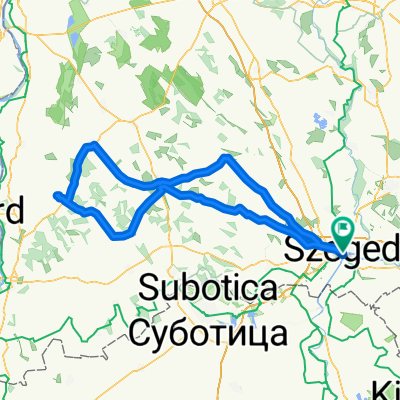
1.nap_Szeged-Bácsalmás (Sárga Csikó panzió)
A cycling route starting in Szeged, Csongrád megye, Hungary.
Overview
About this route
- -:--
- Duration
- 88.4 km
- Distance
- 89 m
- Ascent
- 50 m
- Descent
- ---
- Avg. speed
- ---
- Avg. speed

Route quality
Waytypes & surfaces along the route
Waytypes
Busy road
50.3 km
(57 %)
Cycleway
26.2 km
(30 %)
Surfaces
Paved
84.6 km
(96 %)
Unpaved
1 km
(1 %)
Asphalt
82.5 km
(93 %)
Paving stones
1.8 km
(2 %)
Continue with Bikemap
Use, edit, or download this cycling route
You would like to ride 1.nap_Szeged-Bácsalmás (Sárga Csikó panzió) or customize it for your own trip? Here is what you can do with this Bikemap route:
Free features
- Save this route as favorite or in collections
- Copy & plan your own version of this route
- Sync your route with Garmin or Wahoo
Premium features
Free trial for 3 days, or one-time payment. More about Bikemap Premium.
- Navigate this route on iOS & Android
- Export a GPX / KML file of this route
- Create your custom printout (try it for free)
- Download this route for offline navigation
Discover more Premium features.
Get Bikemap PremiumFrom our community
Other popular routes starting in Szeged
 From Garam utca 3 loop 9
- Distance
- 71.4 km
- Ascent
- 48 m
- Descent
- 50 m
- Location
- Szeged, Csongrád megye, Hungary
 szeged-hajós
- Distance
- 215 km
- Ascent
- 136 m
- Descent
- 137 m
- Location
- Szeged, Csongrád megye, Hungary
 Szegedi bóklászás
- Distance
- 68 km
- Ascent
- 41 m
- Descent
- 41 m
- Location
- Szeged, Csongrád megye, Hungary
 Nagy Kömpöc
- Distance
- 125.8 km
- Ascent
- 67 m
- Descent
- 66 m
- Location
- Szeged, Csongrád megye, Hungary
 80km szeged
- Distance
- 82.6 km
- Ascent
- 62 m
- Descent
- 64 m
- Location
- Szeged, Csongrád megye, Hungary
 Csongrádi sugárút, Szeged to Csongrádi sugárút, Szeged
- Distance
- 52.8 km
- Ascent
- 51 m
- Descent
- 51 m
- Location
- Szeged, Csongrád megye, Hungary
 Tisza Maraton útvonal terv 2011 Közép
- Distance
- 61.2 km
- Ascent
- 52 m
- Descent
- 51 m
- Location
- Szeged, Csongrád megye, Hungary
 Piknik a Mélyponton (75,8m tengerszint felett)
- Distance
- 23.8 km
- Ascent
- 25 m
- Descent
- 27 m
- Location
- Szeged, Csongrád megye, Hungary
Open it in the app